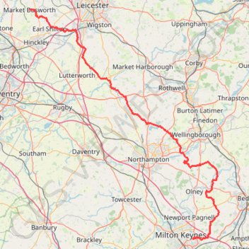
The Jo Cox Way 2022 Day 3 Market Bosworth to Milton Keynes
- Distance: 122.9 Km
- Elevation gain: 953 m
- Maximum elevation: 195 m
- Elevation loss: 1,008 m
- Minimum elevation: 41 m
- Moving time: 5 h 37 m
- Moving speed: 21.8 Km/h
- Maximum speed: 46.4 Km/h
- Total time: 5 h 37 m
- Global speed: 21.8 Km/h
Interactive trail map
Trail profile
- Distance: 122.9 Km
- Elevation gain: 953 m
- Maximum elevation: 195 m
- Elevation loss: 1,008 m
- Minimum elevation: 41 m
- Moving time: 5 h 37 m
- Moving speed: 21.8 Km/h
- Maximum speed: 46.4 Km/h
- Total time: 5 h 37 m
- Global speed: 21.8 Km/h
About this trail
Name: The Jo Cox Way 2022 Day 3 Market Bosworth to Milton Keynes trail, distance, elevation, map, profile, GPS track
Coordinates: 52.02791 -1.39915 52.62595 -0.59400
Other hiking, mountain biking, running and outdoor activity trails
Click on a trail to view its statistics, map and profile.
Loop walk along River Nene around Chester House area
United Kingdom > England > North Northamptonshire > Little Irchester
Distance: 1.8 Km • Elevation gain: 8 m • Maximum elevation: 47 m
Walk from Irthlingborough to Rushden Lakes in Nene Wetlands Nature Reserve
United Kingdom > England > North Northamptonshire > Wellingborough
Distance: 3.5 Km • Elevation gain: 14 m • Maximum elevation: 43 m
Wellingborough Waendel Walk walk
United Kingdom > England > North Northamptonshire > Wellingborough > Little Irchester
Distance: 16.2 Km • Elevation gain: 141 m • Maximum elevation: 102 m
42 Km walk around Wellingborough
United Kingdom > England > North Northamptonshire > Wellingborough > Little Irchester
Distance: 41.7 Km • Elevation gain: 308 m • Maximum elevation: 115 m
Walking from Kettering to Northampton via various PRoW paths
United Kingdom > England > North Northamptonshire > Kettering
Distance: 27.5 Km • Elevation gain: 267 m • Maximum elevation: 117 m
The Jo Cox Way 2022 Day 4 - Milton Keynes to Uxbridge
United Kingdom > England > City of Milton Keynes > Milton Keynes > Monkston
Distance: 104.4 Km • Elevation gain: 1,038 m • Maximum elevation: 251 m
Walk from Kettering to Corby
United Kingdom > England > North Northamptonshire > Kettering
Distance: 12.8 Km • Elevation gain: 142 m • Maximum elevation: 121 m
Banbury ➡️ Mollington ➡️ Cropredy ➡️ Banbury
United Kingdom > England > Oxfordshire > Cherwell District > Banbury
Distance: 21.9 Km • Elevation gain: 214 m • Maximum elevation: 164 m
The JCW 23 - Cranfield to Uxbridge
United Kingdom > England > Central Bedfordshire > Cranfield
Distance: 90.1 Km • Elevation gain: 863 m • Maximum elevation: 266 m
Cycling around Kettering
United Kingdom > England > North Northamptonshire > Kettering
Kettering Cycling
Distance: 36.0 Km • Elevation gain: 360 m • Maximum elevation: 127 m
Moors Lane via Houlton Way
United Kingdom > England > Warwickshire > Rugby > Clifton upon Dunsmore CP
Distance: 11.4 Km • Elevation gain: 101 m • Maximum elevation: 110 m
Cycle tour of Hinckley
United Kingdom > England > Leicestershire > Hinckley and Bosworth > Hinckley
cycling, hinckley
Distance: 12.3 Km • Elevation gain: 79 m • Maximum elevation: 139 m
Parks and Ride Stony
United Kingdom > England > City of Milton Keynes > Milton Keynes > Wolverton
Milton Keynes Cycling
Distance: 9.9 Km • Elevation gain: 51 m • Maximum elevation: 90 m
Kettering Half Marathon
United Kingdom > England > North Northamptonshire > Kettering
Distance: 21.1 Km • Elevation gain: 185 m • Maximum elevation: 110 m
Radway 🔁 Mollington
United Kingdom > England > Warwickshire > Stratford-on-Avon > Radway
Distance: 23.4 Km • Elevation gain: 430 m • Maximum elevation: 218 m
Isham Footpath
United Kingdom > England > North Northamptonshire > Kettering
Evening Run
Distance: 10.2 Km • Elevation gain: 111 m • Maximum elevation: 86 m
JCW25 Day 4
United Kingdom > England > Central Bedfordshire > Cranfield
Distance: 105.9 Km • Elevation gain: 965 m • Maximum elevation: 266 m
Route
United Kingdom > England > Central Bedfordshire > Upper Sundon
Distance: 113.0 Km • Elevation gain: 903 m • Maximum elevation: 170 m
R SP900970
United Kingdom > England > Rutland > Thorpe by Water
Distance: 1.0 Km • Elevation gain: 8 m • Maximum elevation: 51 m