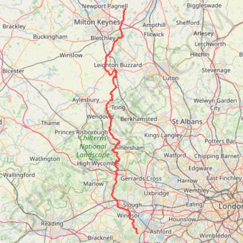
JCW25 Day 4
- Distance: 105.9 Km
- Elevation gain: 965 m
- Maximum elevation: 266 m
- Elevation loss: 1,006 m
- Minimum elevation: 18 m
Interactive trail map
Trail profile
- Distance: 105.9 Km
- Elevation gain: 965 m
- Maximum elevation: 266 m
- Elevation loss: 1,006 m
- Minimum elevation: 18 m
About this trail
Name: JCW25 Day 4 trail, distance, elevation, map, profile, GPS track
Start: College Road, Cranfield, Central Bedfordshire, England, MK43 0AJ, United Kingdom (52.07563 -0.62441)
Coordinates: 51.42477 -0.72298 52.07563 -0.56757
Other hiking, mountain biking, running and outdoor activity trails
Click on a trail to view its statistics, map and profile.
The Jo Cox Way 2022 Day 4 - Milton Keynes to Uxbridge
United Kingdom > England > City of Milton Keynes > Milton Keynes > Monkston
Distance: 104.4 Km • Elevation gain: 1,038 m • Maximum elevation: 251 m
The Jo Cox Way 2022 Day 3 Market Bosworth to Milton Keynes
United Kingdom > England > Leicestershire > Hinckley and Bosworth > Market Bosworth
Distance: 122.9 Km • Elevation gain: 953 m • Maximum elevation: 195 m
The JCW 23 - Cranfield to Uxbridge
United Kingdom > England > Central Bedfordshire > Cranfield
Distance: 90.1 Km • Elevation gain: 863 m • Maximum elevation: 266 m
Dockey Woods
United Kingdom > England > Buckinghamshire > Ivinghoe
Distance: 9.7 Km • Elevation gain: 150 m • Maximum elevation: 251 m
Ivinghoe Beacon
United Kingdom > England > Buckinghamshire > Dacorum
Distance: 8.2 Km • Elevation gain: 148 m • Maximum elevation: 251 m
Route
United Kingdom > England > Central Bedfordshire > Upper Sundon
Distance: 113.0 Km • Elevation gain: 903 m • Maximum elevation: 170 m