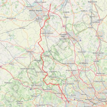
The JCW 23 - Cranfield to Uxbridge
- Distance: 90.1 Km
- Elevation gain: 863 m
- Maximum elevation: 266 m
- Elevation loss: 929 m
- Minimum elevation: 32 m
- Moving time: 4 h 13 m
- Moving speed: 21.3 Km/h
- Maximum speed: 53.5 Km/h
- Total time: 4 h 13 m
- Global speed: 21.3 Km/h
Interactive trail map
Trail profile
- Distance: 90.1 Km
- Elevation gain: 863 m
- Maximum elevation: 266 m
- Elevation loss: 929 m
- Minimum elevation: 32 m
- Moving time: 4 h 13 m
- Moving speed: 21.3 Km/h
- Maximum speed: 53.5 Km/h
- Total time: 4 h 13 m
- Global speed: 21.3 Km/h
About this trail
Name: The JCW 23 - Cranfield to Uxbridge trail, distance, elevation, map, profile, GPS track
Start: Duncan Road, Cranfield, Central Bedfordshire, England, MK43 0TQ, United Kingdom (52.07545 -0.62469)
Coordinates: 51.53298 -0.73868 52.07545 -0.46751
Other hiking, mountain biking, running and outdoor activity trails
Click on a trail to view its statistics, map and profile.
The Rye
United Kingdom > England > Buckinghamshire > High Wycombe
Distance: 1.6 Km • Elevation gain: 23 m • Maximum elevation: 78 m
The Jo Cox Way 2022 Day 4 - Milton Keynes to Uxbridge
United Kingdom > England > City of Milton Keynes > Milton Keynes > Monkston
Distance: 104.4 Km • Elevation gain: 1,038 m • Maximum elevation: 251 m
The Jo Cox Way 2022 Day 3 Market Bosworth to Milton Keynes
United Kingdom > England > Leicestershire > Hinckley and Bosworth > Market Bosworth
Distance: 122.9 Km • Elevation gain: 953 m • Maximum elevation: 195 m
Dockey Woods
United Kingdom > England > Buckinghamshire > Ivinghoe
Distance: 9.7 Km • Elevation gain: 150 m • Maximum elevation: 251 m
Ivinghoe Beacon
United Kingdom > England > Buckinghamshire > Dacorum
Distance: 8.2 Km • Elevation gain: 148 m • Maximum elevation: 251 m
JCW25 Day 4
United Kingdom > England > Central Bedfordshire > Cranfield
Distance: 105.9 Km • Elevation gain: 965 m • Maximum elevation: 266 m
Flitwick
United Kingdom > England > Central Bedfordshire > Flitwick
Distance: 16.6 Km • Elevation gain: 142 m • Maximum elevation: 111 m
Route
United Kingdom > England > Central Bedfordshire > Upper Sundon
Distance: 113.0 Km • Elevation gain: 903 m • Maximum elevation: 170 m