Make a donation
Gear up for your next adventure:
As an Amazon Associate, this site earns from qualifying purchases at no extra cost to you.
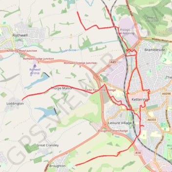
Cycling around Kettering
Kettering Cycling
- Distance: 36.0 Km
- Elevation gain: 360 m
- Maximum elevation: 127 m
- Elevation loss: 360 m
- Minimum elevation: 62 m
- Moving time: 2 h 32 m
- Moving speed: 14.2 Km/h
- Maximum speed: 39.3 Km/h
- Total time: 2 h 55 m
- Global speed: 12.3 Km/h
Interactive trail map
Make a donation
Gear up for your next adventure:
As an Amazon Associate, this site earns from qualifying purchases at no extra cost to you.
Trail profile
- Distance: 36.0 Km
- Elevation gain: 360 m
- Maximum elevation: 127 m
- Elevation loss: 360 m
- Minimum elevation: 62 m
- Moving time: 2 h 32 m
- Moving speed: 14.2 Km/h
- Maximum speed: 39.3 Km/h
- Total time: 2 h 55 m
- Global speed: 12.3 Km/h
Make a donation
Gear up for your next adventure:
As an Amazon Associate, this site earns from qualifying purchases at no extra cost to you.
About this trail
Name: Cycling around Kettering trail, distance, elevation, map, profile, GPS track
Coordinates: 52.37554 -0.79758 52.43286 -0.72208
Make a donation
Gear up for your next adventure:
As an Amazon Associate, this site earns from qualifying purchases at no extra cost to you.
Other hiking, mountain biking, running and outdoor activity trails
Click on a trail to view its statistics, map and profile.
Walking from Kettering to Northampton via various PRoW paths
United Kingdom > England > North Northamptonshire > Kettering
Distance: 27.5 Km • Elevation gain: 267 m • Maximum elevation: 117 m
The Jo Cox Way 2022 Day 3 Market Bosworth to Milton Keynes
United Kingdom > England > Leicestershire > Hinckley and Bosworth > Market Bosworth
Distance: 122.9 Km • Elevation gain: 953 m • Maximum elevation: 195 m
Kettering Half Marathon
United Kingdom > England > North Northamptonshire > Kettering
Distance: 21.1 Km • Elevation gain: 185 m • Maximum elevation: 110 m
Walk from Kettering to Corby
United Kingdom > England > North Northamptonshire > Kettering
Distance: 12.8 Km • Elevation gain: 142 m • Maximum elevation: 121 m
Make a donation
Gear up for your next adventure:
As an Amazon Associate, this site earns from qualifying purchases at no extra cost to you.