Make a donation
Gear up for your next adventure:
As an Amazon Associate, this site earns from qualifying purchases at no extra cost to you.
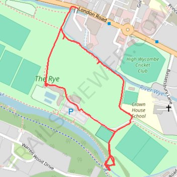
The Rye
- Distance: 1.6 Km
- Elevation gain: 23 m
- Maximum elevation: 78 m
- Elevation loss: 21 m
- Minimum elevation: 62 m
- Moving time: 27 m 24 s
- Moving speed: 3.4 Km/h
- Maximum speed: 5.6 Km/h
- Total time: 1 h 58 m
- Global speed: 0.8 Km/h
Interactive trail map
Make a donation
Gear up for your next adventure:
As an Amazon Associate, this site earns from qualifying purchases at no extra cost to you.
Trail profile
- Distance: 1.6 Km
- Elevation gain: 23 m
- Maximum elevation: 78 m
- Elevation loss: 21 m
- Minimum elevation: 62 m
- Moving time: 27 m 24 s
- Moving speed: 3.4 Km/h
- Maximum speed: 5.6 Km/h
- Total time: 1 h 58 m
- Global speed: 0.8 Km/h
Make a donation
Gear up for your next adventure:
As an Amazon Associate, this site earns from qualifying purchases at no extra cost to you.
About this trail
Name: The Rye trail, distance, elevation, map, profile, GPS track
Coordinates: 51.62150 -0.73941 51.62594 -0.73563
Make a donation
Gear up for your next adventure:
As an Amazon Associate, this site earns from qualifying purchases at no extra cost to you.
Other hiking, mountain biking, running and outdoor activity trails
Click on a trail to view its statistics, map and profile.
The Jo Cox Way 2022 Day 4 - Milton Keynes to Uxbridge
United Kingdom > England > City of Milton Keynes > Milton Keynes > Monkston
Distance: 104.4 Km • Elevation gain: 1,038 m • Maximum elevation: 251 m
The JCW 23 - Cranfield to Uxbridge
United Kingdom > England > Central Bedfordshire > Cranfield
Distance: 90.1 Km • Elevation gain: 863 m • Maximum elevation: 266 m