Make a donation
Gear up for your next adventure:
As an Amazon Associate, this site earns from qualifying purchases at no extra cost to you.
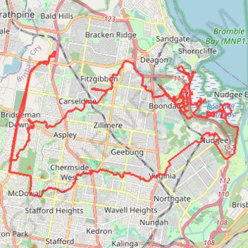
Downfall Creek - Cabbage Tree Creek
Interactive trail map
Make a donation
Gear up for your next adventure:
As an Amazon Associate, this site earns from qualifying purchases at no extra cost to you.
Trail profile
- Distance: 80.6 Km
- Elevation gain: 464 m
- Maximum elevation: 65 m
- Elevation loss: 465 m
- Minimum elevation: 0 m
Make a donation
Gear up for your next adventure:
As an Amazon Associate, this site earns from qualifying purchases at no extra cost to you.
About this trail
Name: Downfall Creek - Cabbage Tree Creek trail, distance, elevation, map, profile, GPS track
Start: 52, Miles Street, Bald Hills, City of Brisbane, Queensland, 4036, Australia (-27.32638 153.01128)
End: 54, Miles Street, Bald Hills, City of Brisbane, Queensland, 4036, Australia (-27.32640 153.01158)
Coordinates: -27.39007 152.98896 -27.32638 153.10223
Topography: City of Brisbane topographic map, elevation, terrain
Make a donation
Gear up for your next adventure:
As an Amazon Associate, this site earns from qualifying purchases at no extra cost to you.
Other hiking, mountain biking, running and outdoor activity trails
Click on a trail to view its statistics, map and profile.
Make a donation
Gear up for your next adventure:
As an Amazon Associate, this site earns from qualifying purchases at no extra cost to you.
Bunyaville Conservation Park
Australia > Queensland > City of Brisbane
#MTB #Loop #Bunyaville
Distance: 47.9 Km • Elevation gain: 523 m • Maximum elevation: 106 m
Make a donation
Gear up for your next adventure:
As an Amazon Associate, this site earns from qualifying purchases at no extra cost to you.
Make a donation
Gear up for your next adventure:
As an Amazon Associate, this site earns from qualifying purchases at no extra cost to you.
Deagan wetlands Sandgate
Australia > Queensland > City of Brisbane
Brisbane Trail Run
Distance: 16.2 Km • Elevation gain: 64 m • Maximum elevation: 22 m