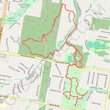
Chermside West Circuit
Interactive trail map
Trail profile
- Distance: 9.2 Km
- Elevation gain: 161 m
- Maximum elevation: 88 m
- Elevation loss: 161 m
- Minimum elevation: 35 m
About this trail
Name: Chermside West Circuit trail, distance, elevation, map, profile, GPS track
Coordinates: -27.38968 152.99393 -27.37070 153.00774
Topography: City of Brisbane topographic map, elevation, terrain
Other hiking, mountain biking, running and outdoor activity trails
Click on a trail to view its statistics, map and profile.
Bunyaville Conservation Park
Australia > Queensland > City of Brisbane
#MTB #Loop #Bunyaville
Distance: 47.9 Km • Elevation gain: 523 m • Maximum elevation: 106 m