Make a donation
Gear up for your next adventure:
As an Amazon Associate, this site earns from qualifying purchases at no extra cost to you.
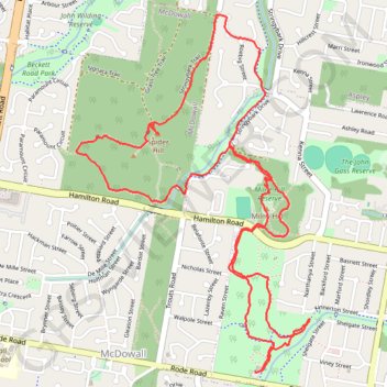
Raven Street Reserve - Chermside Hills Reserve
Interactive trail map
Make a donation
Gear up for your next adventure:
As an Amazon Associate, this site earns from qualifying purchases at no extra cost to you.
Trail profile
- Distance: 8.9 Km
- Elevation gain: 160 m
- Maximum elevation: 89 m
- Elevation loss: 160 m
- Minimum elevation: 35 m
Make a donation
Gear up for your next adventure:
As an Amazon Associate, this site earns from qualifying purchases at no extra cost to you.
About this trail
Name: Raven Street Reserve - Chermside Hills Reserve trail, distance, elevation, map, profile, GPS track
Coordinates: -27.38964 152.99396 -27.37071 153.00793
Topography: City of Brisbane topographic map, elevation, terrain
Make a donation
Gear up for your next adventure:
As an Amazon Associate, this site earns from qualifying purchases at no extra cost to you.
Other hiking, mountain biking, running and outdoor activity trails
Click on a trail to view its statistics, map and profile.
Make a donation
Gear up for your next adventure:
As an Amazon Associate, this site earns from qualifying purchases at no extra cost to you.
Bunyaville Conservation Park
Australia > Queensland > City of Brisbane
#MTB #Loop #Bunyaville
Distance: 47.9 Km • Elevation gain: 523 m • Maximum elevation: 106 m