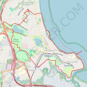
Deagan wetlands Sandgate
Brisbane Trail Run
- Distance: 16.2 Km
- Elevation gain: 64 m
- Maximum elevation: 22 m
- Elevation loss: 65 m
- Minimum elevation: 0 m
- Moving time: 1 h 24 m
- Moving speed: 11.4 Km/h
- Maximum speed: 18.0 Km/h
- Total time: 1 h 24 m
- Global speed: 11.4 Km/h
Interactive trail map
Trail profile
- Distance: 16.2 Km
- Elevation gain: 64 m
- Maximum elevation: 22 m
- Elevation loss: 65 m
- Minimum elevation: 0 m
- Moving time: 1 h 24 m
- Moving speed: 11.4 Km/h
- Maximum speed: 18.0 Km/h
- Total time: 1 h 24 m
- Global speed: 11.4 Km/h
About this trail
Name: Deagan wetlands Sandgate trail, distance, elevation, map, profile, GPS track
Coordinates: -27.33377 153.04536 -27.30118 153.08816
Topography: City of Brisbane topographic map, elevation, terrain
Other hiking, mountain biking, running and outdoor activity trails
Click on a trail to view its statistics, map and profile.