Old Rag Mountain Loop via Ridge Trail, saddle Trail and Weakley Hollow Fire Road
The Old Rag Mountain Loop offers one of the most iconic and challenging hiking experiences in Shenandoah National Park, featuring rocky scrambles, expansive views, and a rewarding sense of accomplishment. Hikers are treated to panoramic vistas from the summit, where the rugged Blue Ridge Mountains unfold in all directions, and the descent along the Saddle Trail and Weakley Hollow Fire Road reveals tranquil forests and winding paths. This strenuous route combines technical rock climbing sections with beautiful natural scenery, making it ideal for experienced hikers seeking adventure. #Hiking #Mountain #Forest #Nature #Loop #Rock
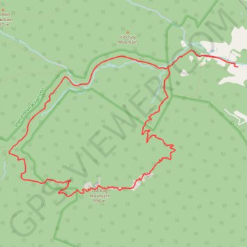
- Distance: 14.6 Km
- Elevation gain: 753 m
- Maximum elevation: 990 m
- Elevation loss: 755 m
- Minimum elevation: 255 m
Interactive trail map
Trail profile
- Distance: 14.6 Km
- Elevation gain: 753 m
- Maximum elevation: 990 m
- Elevation loss: 755 m
- Minimum elevation: 255 m
About this trail
Name: Old Rag Mountain Loop via Ridge Trail, saddle Trail and Weakley Hollow Fire Road trail, distance, elevation, map, profile, GPS track
Start: 2591, Nethers Road, Nethers, Madison County, Virginia, 22740, United States (38.57097 -78.28705)
Coordinates: 38.55007 -78.33231 38.57304 -78.28640
Other hiking, mountain biking, running and outdoor activity trails
Click on a trail to view its statistics, map and profile.
Old Rag Mountain Loop Trail in Shenandoah National Park
United States > Virginia > Madison County
The Old Rag Mountain Loop Trail is a thrilling hike known for its mix of intense rock scrambles and panoramic views from the summit. Starting with a steep ascent, the Ridge Trail leads you through some fun yet challenging rock formations, requiring both hands and feet for maneuvering. Once you reach the…
Distance: 14.9 Km • Elevation gain: 818 m • Maximum elevation: 991 m
Loop hike via Weakley Hollow, White Oak Canyon, Hawksbill, Appalachian Trailand Old Rag in Shenandoah National Park
United States > Virginia > Madison County
Distance: 35.1 Km • Elevation gain: 1,446 m • Maximum elevation: 1,217 m