Old Rag Mountain Loop Trail in Shenandoah National Park
The Old Rag Mountain Loop Trail is a thrilling hike known for its mix of intense rock scrambles and panoramic views from the summit. Starting with a steep ascent, the Ridge Trail leads you through some fun yet challenging rock formations, requiring both hands and feet for maneuvering. Once you reach the summit, you'll be rewarded with breathtaking 360-degree views of the surrounding Blue Ridge Mountains and valleys, making the tough climb well worth it. The descent via the Saddle Trail is more mellow, and you'll pass serene forested areas and cascading streams before circling back to the trailhead. #Hiking #Loop #Mountain #Forest #Nature #Rock
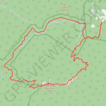
- Distance: 14.9 Km
- Elevation gain: 818 m
- Maximum elevation: 991 m
- Elevation loss: 817 m
- Minimum elevation: 291 m
- Moving time: 3 h 40 m
- Moving speed: 4.1 Km/h
- Maximum speed: 13.9 Km/h
- Total time: 4 h 26 m
- Global speed: 3.3 Km/h
Interactive trail map
Trail profile
- Distance: 14.9 Km
- Elevation gain: 818 m
- Maximum elevation: 991 m
- Elevation loss: 817 m
- Minimum elevation: 291 m
- Moving time: 3 h 40 m
- Moving speed: 4.1 Km/h
- Maximum speed: 13.9 Km/h
- Total time: 4 h 26 m
- Global speed: 3.3 Km/h
About this trail
Name: Old Rag Mountain Loop Trail in Shenandoah National Park trail, distance, elevation, map, profile, GPS track
Start: Old Rag Lower Lot, Nethers Road, Madison County, Virginia, 22719, United States (38.57073 -78.29369)
End: Ridge trail, Madison County, Virginia, 22719, United States (38.57065 -78.29379)
Coordinates: 38.55021 -78.33229 38.57208 -78.29358
Other hiking, mountain biking, running and outdoor activity trails
Click on a trail to view its statistics, map and profile.
Old Rag Mountain Loop via Ridge Trail, saddle Trail and Weakley Hollow Fire Road
United States > Virginia > Madison County > Nethers
The Old Rag Mountain Loop offers one of the most iconic and challenging hiking experiences in Shenandoah National Park, featuring rocky scrambles, expansive views, and a rewarding sense of accomplishment. Hikers are treated to panoramic vistas from the summit, where the rugged Blue Ridge Mountains unfold in…
Distance: 14.6 Km • Elevation gain: 753 m • Maximum elevation: 990 m
Loop hike via Weakley Hollow, White Oak Canyon, Hawksbill, Appalachian Trailand Old Rag in Shenandoah National Park
United States > Virginia > Madison County
Distance: 35.1 Km • Elevation gain: 1,446 m • Maximum elevation: 1,217 m