Old Rag Mountain Loop
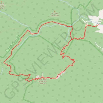
Interactive trail map
Trail profile
- Distance: 15.4 Km
- Elevation gain: 847 m
- Maximum elevation: 990 m
- Elevation loss: 847 m
- Minimum elevation: 257 m
About this trail
Name: Old Rag Mountain Loop trail, distance, elevation, map, profile, GPS track
Start: 2624, Nethers Road, Nethers, Madison County, Virginia, 22740, United States (38.57103 -78.28751)
End: 2624, Nethers Road, Nethers, Madison County, Virginia, 22740, United States (38.57103 -78.28751)
Coordinates: 38.55018 -78.33230 38.57212 -78.28751
Other hiking, mountain biking, running and outdoor activity trails
Click on a trail to view its statistics, map and profile.
Old Rag Mountain Loop via Ridge Trail, saddle Trail and Weakley Hollow Fire Road
United States > Virginia > Madison County > Nethers
The Old Rag Mountain Loop offers one of the most iconic and challenging hiking experiences in Shenandoah National Park, featuring rocky scrambles, expansive views, and a rewarding sense of accomplishment. Hikers are treated to panoramic vistas from the summit, where the rugged Blue Ridge Mountains unfold in…
Distance: 14.6 Km • Elevation gain: 753 m • Maximum elevation: 990 m
Old Rag Mountain Loop Trail in Shenandoah National Park
United States > Virginia > Madison County
The Old Rag Mountain Loop Trail is a thrilling hike known for its mix of intense rock scrambles and panoramic views from the summit. Starting with a steep ascent, the Ridge Trail leads you through some fun yet challenging rock formations, requiring both hands and feet for maneuvering. Once you reach the…
Distance: 14.9 Km • Elevation gain: 818 m • Maximum elevation: 991 m
Loop hike via Weakley Hollow, White Oak Canyon, Hawksbill, Appalachian Trailand Old Rag in Shenandoah National Park
United States > Virginia > Madison County
Distance: 35.1 Km • Elevation gain: 1,446 m • Maximum elevation: 1,217 m