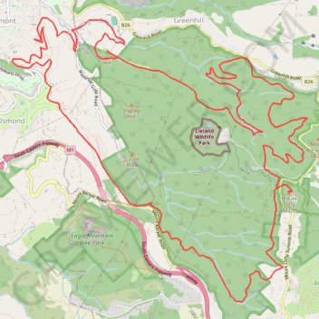
Tour of Cleland Conservation Park
Interactive trail map
Trail profile
- Distance: 27.6 Km
- Elevation gain: 1,106 m
- Maximum elevation: 706 m
- Elevation loss: 1,106 m
- Minimum elevation: 180 m
About this trail
Name: Tour of Cleland Conservation Park trail, distance, elevation, map, profile, GPS track
Coordinates: -34.98941 138.66167 -34.94957 138.71220
Topography: Adelaide topographic map, elevation, terrain
Other hiking, mountain biking, running and outdoor activity trails
Click on a trail to view its statistics, map and profile.
Belair National Park - Mount Lofty
Australia > South Australia > Adelaide
#Bike
Distance: 13.0 Km • Elevation gain: 503 m • Maximum elevation: 704 m