Make a donation
Gear up for your next adventure:
As an Amazon Associate, this site earns from qualifying purchases at no extra cost to you.
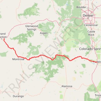
2026-04-11_20-46_Sat
- Distance: 453.8 Km
- Elevation gain: 5,352 m
- Maximum elevation: 3,457 m
- Elevation loss: 5,378 m
- Minimum elevation: 1,410 m
Interactive trail map
Make a donation
Gear up for your next adventure:
As an Amazon Associate, this site earns from qualifying purchases at no extra cost to you.
Trail profile
- Distance: 453.8 Km
- Elevation gain: 5,352 m
- Maximum elevation: 3,457 m
- Elevation loss: 5,378 m
- Minimum elevation: 1,410 m
Make a donation
Gear up for your next adventure:
As an Amazon Associate, this site earns from qualifying purchases at no extra cost to you.
About this trail
Name: 2026-04-11_20-46_Sat trail, distance, elevation, map, profile, GPS track
End: 493, 32 1/8 Road, Clifton, Mesa County, Colorado, 81520, United States (39.07609 -108.45674)
Coordinates: 38.30753 -108.47452 39.07615 -104.61299
Make a donation
Gear up for your next adventure:
As an Amazon Associate, this site earns from qualifying purchases at no extra cost to you.
Other hiking, mountain biking, running and outdoor activity trails
Click on a trail to view its statistics, map and profile.
Palmer, Cabin Canyon, Strausenbach, Scotsman, and Central Gardens Trails Loop
United States > Colorado > El Paso County > Colorado Springs
The Palmer, Cabin Canyon, Strausenbach, Scotsman, and Central Gardens Trails Loop in Garden of the Gods offers a diverse hiking experience through some of Colorado's most iconic landscapes. This route guides you past striking red rock formations such as the Kissing Camels and Sentinel Spires, while providing…
Distance: 6.9 Km • Elevation gain: 194 m • Maximum elevation: 2,016 m
Devil's Playground via Crags to Devils Playground Trail in Pike National Forest
United States > Colorado > Teller County
The hike from Crags to Devil's Playground offers a rugged yet awe-inspiring experience in Pike National Forest, providing a blend of forest trails, alpine meadows, and sweeping mountain views. As the trail climbs gradually, hikers encounter beautiful vistas of the Rampart Range and Pikes Peak, with striking…
Distance: 12.9 Km • Elevation gain: 900 m • Maximum elevation: 3,941 m
Garden of the Gods Park Loop via Palmer, Buckskin Charlie, Niobrara and Bretag Trails
United States > Colorado > El Paso County > Colorado Springs
The Garden of the Gods Park Loop, traversing the Palmer, Buckskin Charlie, Niobrara, and Bretag Trails, offers hikers an immersive experience amidst striking red rock formations. Along this loop, you'll encounter iconic geological features such as Pikes Peak, the Central Garden formations, and the Siamese…
Distance: 6.5 Km • Elevation gain: 161 m • Maximum elevation: 2,017 m
Castle Peak via Montezuma Basin Road and Castle Peak Trail in Maroon Bells–Snowmass Wilderness Area
United States > Colorado > Pitkin County
The Castle Peak hike via Montezuma Basin Road offers a beautiful yet challenging journey through the heart of Colorado's Elk Mountains. Starting from the rugged Montezuma Basin Road, hikers are treated to panoramic views of alpine meadows, towering peaks, and remnants of mining history. Along the route,…
Distance: 4.9 Km • Elevation gain: 919 m • Maximum elevation: 4,331 m
Make a donation
Gear up for your next adventure:
As an Amazon Associate, this site earns from qualifying purchases at no extra cost to you.
Section 16 Loop Trail via Palmer Red Rock Trail in Bear Creek Cañon Park
United States > Colorado > El Paso County
The Section 16 Loop Trail via the Palmer Red Rock Trail in Bear Creek Cañon Park offers hikers a diverse experience, beginning with exposed red rock formations that provide expansive views of the surrounding canyons and the Front Range peaks. As the trail ascends, it transitions into shaded ponderosa pine…
Distance: 9.5 Km • Elevation gain: 457 m • Maximum elevation: 2,402 m
Mesa Trail, Greenlee Trail, and Red Rock Canyon Trail Loop in Red Rock Canyon Open Space
United States > Colorado > El Paso County > Colorado Springs
The Mesa, Greenlee, and Red Rock Canyon Trails Loop in Colorado Springs offers a pleasant hike through Red Rock Canyon Open Space, combining gentle inclines and peaceful scenery. The trail features expansive views of Garden of the Gods, a tranquil pond, and unique sandstone formations shaped by historic…
Distance: 2.9 Km • Elevation gain: 69 m • Maximum elevation: 1,941 m
The Manitou Incline loop hike in Pike National Forest
United States > Colorado > El Paso County > Manitou Springs
The Incline is a thrilling challenge that gains about 2,000 feet in just a mile. As you ascend, you'll navigate steep steps and rugged terrain, but the panoramic views of Colorado Springs from the top are absolutely breathtaking and make every hard-earned step worth it. The descent via Barr Trail offers a…
Distance: 6.9 Km • Elevation gain: 624 m • Maximum elevation: 2,613 m
St. Mary's Falls Trail in Pike National Forest
United States > Colorado > El Paso County
The St. Mary’s Falls Trail in Pike National Forest offers a rewarding hike through North Cheyenne Canyon. Beginning on a closed section of Gold Camp Road, the route passes through a mix of aspen and pine forests, offering views of small waterfalls and a flowing creek along the way. The final stretch involves…
Distance: 10.5 Km • Elevation gain: 461 m • Maximum elevation: 2,720 m
Make a donation
Gear up for your next adventure:
As an Amazon Associate, this site earns from qualifying purchases at no extra cost to you.
Central Garden Loop Trail in Garden of the Gods
United States > Colorado > El Paso County > Colorado Springs
The Central Garden Loop Trail in Garden of the Gods offers hikers an unforgettable journey through breathtaking rock formations and lush landscapes. As you walk the trail, you'll encounter towering sandstone spires, massive red rock formations, and striking panoramic views of the surrounding prairie and…
Distance: 1.9 Km • Elevation gain: 39 m • Maximum elevation: 1,976 m
Make a donation
Gear up for your next adventure:
As an Amazon Associate, this site earns from qualifying purchases at no extra cost to you.
Make a donation
Gear up for your next adventure:
As an Amazon Associate, this site earns from qualifying purchases at no extra cost to you.
Mason Trail, Mc Reynolds Reservoir, Mason Reservoir, Boehmer Reservoir, South Slope Recreation Area, Pikes Peak, Colorado
United States > Colorado > Teller County
Distance: 15.9 Km • Elevation gain: 350 m • Maximum elevation: 3,492 m
Kineo Mountain Trail, Upper Bear Creek and Seven Bridges loop hike
United States > Colorado > El Paso County
Distance: 11.6 Km • Elevation gain: 569 m • Maximum elevation: 2,769 m
First time on Dream On, Salida, Colorado
United States > Colorado > Chaffee County > Salida
Distance: 26.6 Km • Elevation gain: 564 m • Maximum elevation: 2,299 m
Make a donation
Gear up for your next adventure:
As an Amazon Associate, this site earns from qualifying purchases at no extra cost to you.
Riding solstice while I can. Salida, co
United States > Colorado > Chaffee County > Salida
Distance: 14.6 Km • Elevation gain: 438 m • Maximum elevation: 2,416 m
Columbine Trail - North Cheyenne Canyon
United States > Colorado > El Paso County
Distance: 2.6 Km • Elevation gain: 82 m • Maximum elevation: 2,032 m
Ladder Extension trail
United States > Colorado > El Paso County > Colorado Springs
North Cheyenne Canyon Park
Distance: 9.7 Km • Elevation gain: 481 m • Maximum elevation: 2,253 m
Chalk Creek 2023 Race Lap
United States > Colorado > Chaffee County > Nathrop
Distance: 10.7 Km • Elevation gain: 173 m • Maximum elevation: 2,451 m
Make a donation
Gear up for your next adventure:
As an Amazon Associate, this site earns from qualifying purchases at no extra cost to you.
Raspberry Mountain Trail
United States > Colorado > Teller County
Distance: 9.6 Km • Elevation gain: 327 m • Maximum elevation: 3,204 m
Chutes Jacks ride
United States > Colorado > El Paso County > Colorado Springs
Afternoon Mountain Bike Ride
Distance: 9.8 Km • Elevation gain: 479 m • Maximum elevation: 2,267 m
Pitkin Area Trails
United States > Colorado > Gunnison County
Distance: 66.7 Km • Elevation gain: 1,886 m • Maximum elevation: 3,407 m
Fooses Reroute
United States > Colorado > Chaffee County
Distance: 16.3 Km • Elevation gain: 51 m • Maximum elevation: 3,637 m
Make a donation
Gear up for your next adventure:
As an Amazon Associate, this site earns from qualifying purchases at no extra cost to you.
Memorial Park
United States > Colorado > El Paso County > Colorado Springs
Distance: 3.3 Km • Elevation gain: 15 m • Maximum elevation: 1,856 m
Next Step CO
United States > Colorado > Park County
Distance: 132.9 Km • Elevation gain: 1,985 m • Maximum elevation: 3,005 m
Chamberlain - North Cheyenne Canyon Park
United States > Colorado > El Paso County > Colorado Springs
Walked the trail
Distance: 1.3 Km • Elevation gain: 55 m • Maximum elevation: 1,995 m
Red Rock Canyon
United States > Colorado > El Paso County > Colorado Springs
Chamberlain Trail
Distance: 1.8 Km • Elevation gain: 82 m • Maximum elevation: 1,967 m
Make a donation
Gear up for your next adventure:
As an Amazon Associate, this site earns from qualifying purchases at no extra cost to you.
Walked the North Cheyenne Canyon trail
United States > Colorado > El Paso County
Distance: 0.9 Km • Elevation gain: 35 m • Maximum elevation: 2,088 m
2026-04-10_07-25_Fri
United States > Colorado > Mesa County > Clifton
Distance: 470.1 Km • Elevation gain: 5,647 m • Maximum elevation: 3,454 m
2025-12-27_09-11_Sat
United States > Colorado > Mesa County > Grand Junction
Distance: 323.4 Km • Elevation gain: 2,644 m • Maximum elevation: 2,443 m
2026-04-13_13-38_Mon
United States > Colorado > Mesa County
Distance: 119.0 Km • Elevation gain: 937 m • Maximum elevation: 1,623 m
Make a donation
Gear up for your next adventure:
As an Amazon Associate, this site earns from qualifying purchases at no extra cost to you.
2026-02-14_14-17_Sat
United States > Colorado > Mesa County
Distance: 139.8 Km • Elevation gain: 2,215 m • Maximum elevation: 2,460 m