Make a donation
Gear up for your next adventure:
As an Amazon Associate, this site earns from qualifying purchases at no extra cost to you.
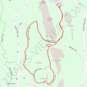
Central Garden Loop Trail in Garden of the Gods
The Central Garden Loop Trail in Garden of the Gods offers hikers an unforgettable journey through breathtaking rock formations and lush landscapes. As you walk the trail, you'll encounter towering sandstone spires, massive red rock formations, and striking panoramic views of the surrounding prairie and distant mountains. Highlights include the towering Kissing Camels and the Cathedral Spires, providing stunning views and excellent photo opportunities. The route also meanders through vibrant wildflower fields and shaded areas, making it a peaceful and scenic trek for nature lovers and outdoor enthusiasts alike. #Hiking #Loop #Rock #Nature
- Distance: 1.9 Km
- Elevation gain: 39 m
- Maximum elevation: 1,976 m
- Elevation loss: 39 m
- Minimum elevation: 1,959 m
- Moving time: 33 m 22 s
- Moving speed: 3.4 Km/h
- Maximum speed: 4.7 Km/h
- Total time: 43 m 22 s
- Global speed: 2.6 Km/h
Interactive trail map
Make a donation
Gear up for your next adventure:
As an Amazon Associate, this site earns from qualifying purchases at no extra cost to you.
Trail profile
- Distance: 1.9 Km
- Elevation gain: 39 m
- Maximum elevation: 1,976 m
- Elevation loss: 39 m
- Minimum elevation: 1,959 m
- Moving time: 33 m 22 s
- Moving speed: 3.4 Km/h
- Maximum speed: 4.7 Km/h
- Total time: 43 m 22 s
- Global speed: 2.6 Km/h
Make a donation
Gear up for your next adventure:
As an Amazon Associate, this site earns from qualifying purchases at no extra cost to you.
About this trail
Name: Central Garden Loop Trail in Garden of the Gods trail, distance, elevation, map, profile, GPS track
Coordinates: 38.87586 -104.88294 38.88088 -104.87978
Make a donation
Gear up for your next adventure:
As an Amazon Associate, this site earns from qualifying purchases at no extra cost to you.
Other hiking, mountain biking, running and outdoor activity trails
Click on a trail to view its statistics, map and profile.
Palmer, Cabin Canyon, Strausenbach, Scotsman, and Central Gardens Trails Loop
United States > Colorado > El Paso County > Colorado Springs
The Palmer, Cabin Canyon, Strausenbach, Scotsman, and Central Gardens Trails Loop in Garden of the Gods offers a diverse hiking experience through some of Colorado's most iconic landscapes. This route guides you past striking red rock formations such as the Kissing Camels and Sentinel Spires, while providing…
Distance: 6.9 Km • Elevation gain: 194 m • Maximum elevation: 2,016 m
Garden of the Gods Park Loop via Palmer, Buckskin Charlie, Niobrara and Bretag Trails
United States > Colorado > El Paso County > Colorado Springs
The Garden of the Gods Park Loop, traversing the Palmer, Buckskin Charlie, Niobrara, and Bretag Trails, offers hikers an immersive experience amidst striking red rock formations. Along this loop, you'll encounter iconic geological features such as Pikes Peak, the Central Garden formations, and the Siamese…
Distance: 6.5 Km • Elevation gain: 161 m • Maximum elevation: 2,017 m
Make a donation
Gear up for your next adventure:
As an Amazon Associate, this site earns from qualifying purchases at no extra cost to you.