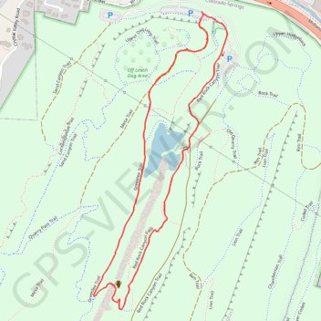
Mesa Trail, Greenlee Trail, and Red Rock Canyon Trail Loop in Red Rock Canyon Open Space
The Mesa, Greenlee, and Red Rock Canyon Trails Loop in Colorado Springs offers a pleasant hike through Red Rock Canyon Open Space, combining gentle inclines and peaceful scenery. The trail features expansive views of Garden of the Gods, a tranquil pond, and unique sandstone formations shaped by historic quarrying activities. Hikers can enjoy the mix of open spaces and shaded paths, making this loop both scenic and accessible for a variety of skill levels. #Hiking #Loop #Rock #Lake #Nature
- Distance: 2.9 Km
- Elevation gain: 69 m
- Maximum elevation: 1,941 m
- Elevation loss: 69 m
- Minimum elevation: 1,883 m
- Moving time: 41 m 51 s
- Moving speed: 4.1 Km/h
- Maximum speed: 9.8 Km/h
- Total time: 45 m 25 s
- Global speed: 3.8 Km/h
Interactive trail map
Trail profile
- Distance: 2.9 Km
- Elevation gain: 69 m
- Maximum elevation: 1,941 m
- Elevation loss: 69 m
- Minimum elevation: 1,883 m
- Moving time: 41 m 51 s
- Moving speed: 4.1 Km/h
- Maximum speed: 9.8 Km/h
- Total time: 45 m 25 s
- Global speed: 3.8 Km/h
About this trail
Name: Mesa Trail, Greenlee Trail, and Red Rock Canyon Trail Loop in Red Rock Canyon Open Space trail, distance, elevation, map, profile, GPS track
Coordinates: 38.84332 -104.88428 38.85351 -104.87840
Other hiking, mountain biking, running and outdoor activity trails
Click on a trail to view its statistics, map and profile.
Red Rock Canyon
United States > Colorado > El Paso County > Colorado Springs
Chamberlain Trail
Distance: 1.8 Km • Elevation gain: 82 m • Maximum elevation: 1,967 m