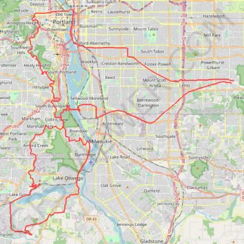
The Watcher in the Water
- Distance: 82.9 Km
- Elevation gain: 1,451 m
- Maximum elevation: 300 m
- Elevation loss: 1,457 m
- Minimum elevation: 3 m
Interactive trail map
Trail profile
- Distance: 82.9 Km
- Elevation gain: 1,451 m
- Maximum elevation: 300 m
- Elevation loss: 1,457 m
- Minimum elevation: 3 m
About this trail
Name: The Watcher in the Water trail, distance, elevation, map, profile, GPS track
Coordinates: 45.38413 -122.72313 45.52806 -122.51993
Other hiking, mountain biking, running and outdoor activity trails
Click on a trail to view its statistics, map and profile.
Lower Macleay Trail and Wildwood Trail to Pittock Mansion
United States > Oregon > Multnomah County > Portland
The hike to Pittock Mansion via the Lower Macleay and Wildwood Trails is an enjoyable route through Portland’s lush Forest Park, offering a variety of natural sights. Starting from Lower Macleay Park, you will pass the Witch's Castle, a unique stone structure hidden in the woods, cross over Balch Creek, and…
Distance: 8.6 Km • Elevation gain: 405 m • Maximum elevation: 295 m
Great Northwest Loop in Washington Park
United States > Oregon > Multnomah County > Portland
The Great Northwest Loop offers a pleasant and scenic escape with a variety of highlights. As you hike, you'll pass through lush forests filled with tall trees, including Douglas-firs and maples, along well-maintained paths that lead to stunning vistas. The route also connects several renowned park…
Distance: 7.2 Km • Elevation gain: 239 m • Maximum elevation: 268 m
Loop hike via Pittock Acres Park, Wilwood Trail, Hoyt Arboretum, Magnolia Trail, Washington Park and Japanes Garden Trail
United States > Oregon > Multnomah County > Portland
Distance: 6.6 Km • Elevation gain: 188 m • Maximum elevation: 250 m
Portland Cyclocross - Happy Valley trails
United States > Oregon > Multnomah County > Portland
Distance: 21.1 Km • Elevation gain: 549 m • Maximum elevation: 321 m
Portland Gravel/Unpaved Cycling
United States > Oregon > Multnomah County > Portland
Distance: 49.8 Km • Elevation gain: 560 m • Maximum elevation: 145 m
Expedition to Sedum Ridge
United States > Oregon > Multnomah County > Portland
Distance: 214.7 Km • Elevation gain: 5,093 m • Maximum elevation: 1,169 m
Lake Oswego trails
United States > Oregon > Multnomah County > Portland
Happy Hour Lake Oswego
Distance: 69.5 Km • Elevation gain: 1,173 m • Maximum elevation: 222 m
3-Creeks Natural Area loop
United States > Oregon > Clackamas County > Milwaukie
Distance: 2.7 Km • Elevation gain: 30 m • Maximum elevation: 43 m