Portland Cyclocross - Happy Valley trails
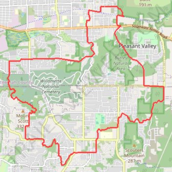
- Distance: 21.1 Km
- Elevation gain: 549 m
- Maximum elevation: 321 m
- Elevation loss: 551 m
- Minimum elevation: 74 m
- Moving time: 1 h 33 m
- Moving speed: 13.5 Km/h
- Maximum speed: 54.3 Km/h
- Total time: 1 h 40 m
- Global speed: 12.6 Km/h
Interactive trail map
Trail profile
- Distance: 21.1 Km
- Elevation gain: 549 m
- Maximum elevation: 321 m
- Elevation loss: 551 m
- Minimum elevation: 74 m
- Moving time: 1 h 33 m
- Moving speed: 13.5 Km/h
- Maximum speed: 54.3 Km/h
- Total time: 1 h 40 m
- Global speed: 12.6 Km/h
About this trail
Name: Portland Cyclocross - Happy Valley trails trail, distance, elevation, map, profile, GPS track
Coordinates: 45.43992 -122.55634 45.48240 -122.49682
Other hiking, mountain biking, running and outdoor activity trails
Click on a trail to view its statistics, map and profile.
Portland Gravel/Unpaved Cycling
United States > Oregon > Multnomah County > Portland
Distance: 49.8 Km • Elevation gain: 560 m • Maximum elevation: 145 m
Expedition to Sedum Ridge
United States > Oregon > Multnomah County > Portland
Distance: 214.7 Km • Elevation gain: 5,093 m • Maximum elevation: 1,169 m
The Watcher in the Water
United States > Oregon > Multnomah County > Portland
Distance: 82.9 Km • Elevation gain: 1,451 m • Maximum elevation: 300 m
Lake Oswego trails
United States > Oregon > Multnomah County > Portland
Happy Hour Lake Oswego
Distance: 69.5 Km • Elevation gain: 1,173 m • Maximum elevation: 222 m