Thank you for supporting this site ❤️
Make a donation
Make a donation
Gear up for your next adventure:
As an Amazon Associate, this site earns from qualifying purchases at no extra cost to you.
Sydney Harbour National Park - Manly to Spit Bridge Walk
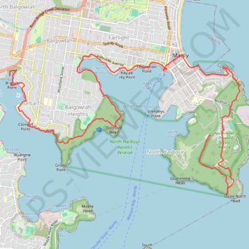
Interactive trail map
Thank you for supporting this site ❤️
Make a donation
Make a donation
Gear up for your next adventure:
As an Amazon Associate, this site earns from qualifying purchases at no extra cost to you.
Trail profile
- Distance: 18.2 Km
- Elevation gain: 483 m
- Maximum elevation: 98 m
- Elevation loss: 411 m
- Minimum elevation: 0 m
- Moving time: 4 h 16 m
- Moving speed: 4.3 Km/h
- Maximum speed: 19.9 Km/h
- Total time: 5 h 42 m
- Global speed: 3.2 Km/h
Thank you for supporting this site ❤️
Make a donation
Make a donation
Gear up for your next adventure:
As an Amazon Associate, this site earns from qualifying purchases at no extra cost to you.
About this trail
Name: Sydney Harbour National Park - Manly to Spit Bridge Walk trail, distance, elevation, map, profile, GPS track
Coordinates: -33.82326 151.24957 -33.79710 151.30129
Topography: Sydney topographic map, elevation, terrain
Thank you for supporting this site ❤️
Make a donation
Make a donation
Gear up for your next adventure:
As an Amazon Associate, this site earns from qualifying purchases at no extra cost to you.
Other hiking, mountain biking, running and outdoor activity trails
Click on a trail to view its statistics, map and profile.