Sentosa Park
Interactive trail map
Trail profile
- Distance: 5.7 Km
- Elevation gain: 137 m
- Maximum elevation: 47 m
- Elevation loss: 120 m
- Minimum elevation: 0 m
About this trail
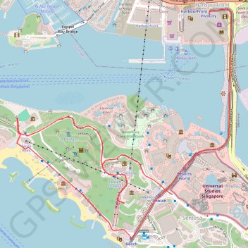
Name: Sentosa Park trail, distance, elevation, map, profile, GPS track
End: Artillery Avenue, Southern Islands, Southwest, Singapore, 098588, Singapore (1.25397 103.82025)
Coordinates: 1.25130 103.81087 1.26516 103.82380
Other hiking, mountain biking, running and outdoor activity trails
Click on a trail to view its statistics, map and profile.
Labrador Park
Distance: 8.0 Km • Elevation gain: 91 m • Maximum elevation: 27 m
Pipeline TGI by AGM
Indonesia > South Sumatra > Tungkal Jaya > Beji Mulyo
Distance: 531.4 Km • Elevation gain: 1,808 m • Maximum elevation: 97 m