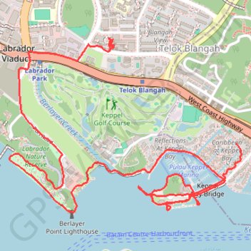
Labrador Park
- Distance: 8.0 Km
- Elevation gain: 91 m
- Maximum elevation: 27 m
- Elevation loss: 77 m
- Minimum elevation: -1 m
Interactive trail map
Trail profile
- Distance: 8.0 Km
- Elevation gain: 91 m
- Maximum elevation: 27 m
- Elevation loss: 77 m
- Minimum elevation: -1 m
About this trail
Name: Labrador Park trail, distance, elevation, map, profile, GPS track
Coordinates: 1.26247 103.80105 1.27379 103.81616
Other hiking, mountain biking, running and outdoor activity trails
Click on a trail to view its statistics, map and profile.
Directions from Duck Tour Ramp to Marina Boulevard, Singapore
Distance: 105.3 Km • Elevation gain: 812 m • Maximum elevation: 51 m