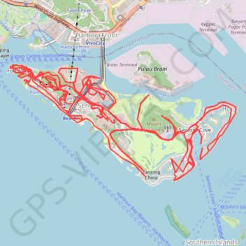
Import a GPX file

Sentosa - Singapore

#Hiking #Loop

  • Distance: 66.8 Km
  • Elevation gain: 1,248 m
  • Maximum elevation: 71 m
  • Elevation loss: 1,244 m
  • Minimum elevation: -1 m

Interactive trail map

👉 Easily get elevation data in JSON, GeoTIFF and KML formats using Elevation API
Thank you for supporting this site ❤️
Make a donation

Gear up for your next adventure:

As an Amazon Associate, this site earns from qualifying purchases at no extra cost to you.

Trail profile

  • Distance: 66.8 Km
  • Elevation gain: 1,248 m
  • Maximum elevation: 71 m
  • Elevation loss: 1,244 m
  • Minimum elevation: -1 m

About this trail

Other hiking, mountain biking, running and outdoor activity trails

Click on a trail to view its statistics, map and profile.

Sentosa Park

Singapore > Singapore

#Hiking #Loop

Distance: 5.7 Km • Elevation gain: 137 m • Maximum elevation: 47 m

Pipeline TGI by AGM

Indonesia > South Sumatra > Tungkal Jaya > Beji Mulyo

Distance: 531.4 Km • Elevation gain: 1,808 m • Maximum elevation: 97 m

Gear up for your next adventure:

🔪Outdoor Multi-tools - Versatile tools for gear repair and survival tasks in the wilderness
💧Personal Water Filters - Drink safely from streams and lakes identified on your map
🧯Animal Deterrent Spray - Safety spray for wildlife
🧢Outdoor Sun Hats - Sun protection hats for hiking
🥾Heavy Duty Hiking Boots - Ankle-supporting boots for carrying heavy packs on steep contours

As an Amazon Associate, this site earns from qualifying purchases at no extra cost to you.