Import a GPX file

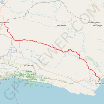
Willowmore - Jeffreys Bay

#Bike

  • Distance: 225.9 Km
  • Elevation gain: 3,576 m
  • Maximum elevation: 1,156 m
  • Elevation loss: 4,305 m
  • Minimum elevation: 10 m

Interactive trail map

Trail profile

  • Distance: 225.9 Km
  • Elevation gain: 3,576 m
  • Maximum elevation: 1,156 m
  • Elevation loss: 4,305 m
  • Minimum elevation: 10 m

About this trail

Other hiking, mountain biking, running and outdoor activity trails

Click on a trail to view its statistics, map and profile.

The Tsitsikamma Big Tree

South Africa > Eastern Cape > Sarah Baartman District Municipality > Kou-Kamma Local Municipality > Stormsrivier

#Hiking #Loop

Distance: 1.2 Km • Elevation gain: 15 m • Maximum elevation: 265 m

Gear up for your next adventure:

🔑Heavy Duty Carabiners - Secure gear to the outside of your pack for easy access
📚Map Reading & Navigation Guides - Master the art of interpreting topographic contours and symbols
🌬️Windbreaker Jackets - Wind protection jackets
🪢550 Survival Paracord - Versatile cordage for gear repair and emergency lashing
🦟Insect Repellent - Protection against insects

As an Amazon Associate, this site earns from qualifying purchases at no extra cost to you.