The Tsitsikamma Big Tree
Interactive trail map
Trail profile
- Distance: 1.2 Km
- Elevation gain: 15 m
- Maximum elevation: 265 m
- Elevation loss: 15 m
- Minimum elevation: 249 m
About this trail
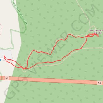
Name: The Tsitsikamma Big Tree trail, distance, elevation, map, profile, GPS track
Coordinates: -33.96627 23.89471 -33.96477 23.89955
Other hiking, mountain biking, running and outdoor activity trails
Click on a trail to view its statistics, map and profile.
Willowmore - Jeffreys Bay
South Africa > Eastern Cape > Sarah Baartman District Municipality > Baviaans Local Municipality > Willowmore
#Bike
Distance: 225.9 Km • Elevation gain: 3,576 m • Maximum elevation: 1,156 m