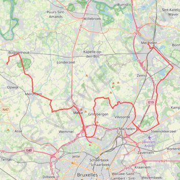
2.1 KOTK 2024
- Distance: 61.7 Km
- Elevation gain: 274 m
- Maximum elevation: 67 m
- Elevation loss: 264 m
- Minimum elevation: 5 m
Interactive trail map
Trail profile
- Distance: 61.7 Km
- Elevation gain: 274 m
- Maximum elevation: 67 m
- Elevation loss: 264 m
- Minimum elevation: 5 m
About this trail
Name: 2.1 KOTK 2024 trail, distance, elevation, map, profile, GPS track
End: Putweg, Opstal, Buggenhout, Dendermonde, East Flanders, Flanders, 9255, Belgium (50.99913 4.17694)
Coordinates: 50.90129 4.17671 51.02808 4.53173
Other hiking, mountain biking, running and outdoor activity trails
Click on a trail to view its statistics, map and profile.
100km Dodentocht 2025 - 56e editie
Belgium > Antwerp > Mechelen > Bornem
Distance: 99.7 Km • Elevation gain: 209 m • Maximum elevation: 24 m
1.1 KOTK 2022
Belgium > Antwerp > Mechelen > Mechelen
Distance: 58.2 Km • Elevation gain: 93 m • Maximum elevation: 27 m
Iedereen 1000 KOTK OVL noordlus 131km met Iben en Jana (eindresultaat deze wk 469km gefietst, 23K gelopen en 12K gewandeld)
Belgium > East Flanders > Gent > Heusden
Distance: 130.2 Km • Elevation gain: 579 m • Maximum elevation: 81 m
Eurovelo 15 - Strasbourg Rotterdam
France > Grand Est > Bas-Rhin > Strasbourg
Distance: 891.7 Km • Elevation gain: 2,104 m • Maximum elevation: 146 m
Track
Belgium > East Flanders > Aalst > Aalst
Distance: 124.2 Km • Elevation gain: 239 m • Maximum elevation: 38 m