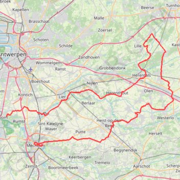
KOTK 2022
- Distance: 124.5 Km
- Elevation gain: 222 m
- Maximum elevation: 28 m
- Elevation loss: 223 m
- Minimum elevation: 2 m
Interactive trail map
Trail profile
- Distance: 124.5 Km
- Elevation gain: 222 m
- Maximum elevation: 28 m
- Elevation loss: 223 m
- Minimum elevation: 2 m
About this trail
Name: KOTK 2022 trail, distance, elevation, map, profile, GPS track
End: Boeimeerstraat, Nekkerspoel, Mechelen, Antwerp, Flanders, 2800, Belgium (51.02792 4.49836)
Coordinates: 51.02622 4.38274 51.26295 4.94292
Other hiking, mountain biking, running and outdoor activity trails
Click on a trail to view its statistics, map and profile.
1.1 KOTK 2022
Belgium > Antwerp > Mechelen > Mechelen
Distance: 58.2 Km • Elevation gain: 93 m • Maximum elevation: 27 m
2.1 KOTK 2024
Belgium > Antwerp > Mechelen > Mechelen
Distance: 61.7 Km • Elevation gain: 274 m • Maximum elevation: 67 m
PR racedayyyy 🏆🥈 10k 32:13
Belgium > Antwerp > Mechelen > Lier
Distance: 10.3 Km • Elevation gain: 18 m • Maximum elevation: 8 m
Eurovelo 15 - Strasbourg Rotterdam
France > Grand Est > Bas-Rhin > Strasbourg
Distance: 891.7 Km • Elevation gain: 2,104 m • Maximum elevation: 146 m
Track
Belgium > East Flanders > Aalst > Aalst
Distance: 124.2 Km • Elevation gain: 239 m • Maximum elevation: 38 m