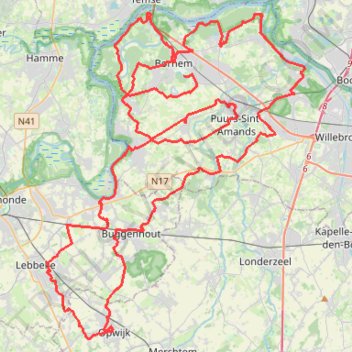
100km Dodentocht 2025 - 56e editie
- Distance: 99.7 Km
- Elevation gain: 209 m
- Maximum elevation: 24 m
- Elevation loss: 205 m
- Minimum elevation: -1 m
Interactive trail map
Trail profile
- Distance: 99.7 Km
- Elevation gain: 209 m
- Maximum elevation: 24 m
- Elevation loss: 205 m
- Minimum elevation: -1 m
About this trail
Name: 100km Dodentocht 2025 - 56e editie trail, distance, elevation, map, profile, GPS track
Start: Breevendreef, Bornem, Mechelen, Antwerp, 2880, Belgium (51.08951 4.24219)
End: Kardinaal Cardijnplein, Bornem, Mechelen, Antwerp, 2880, Belgium (51.09969 4.23508)
Coordinates: 50.96561 4.13862 51.11891 4.33390
Other hiking, mountain biking, running and outdoor activity trails
Click on a trail to view its statistics, map and profile.
SDB-Moerzeke-60k
Belgium > East Flanders > Oudenaarde > Zwalm > Sint-Denijs-Boekel
name=SDB-Moerzeke-60k
Distance: 60.9 Km • Elevation gain: 229 m • Maximum elevation: 60 m
2.1 KOTK 2024
Belgium > Antwerp > Mechelen > Mechelen
Distance: 61.7 Km • Elevation gain: 274 m • Maximum elevation: 67 m
Iedereen 1000 KOTK OVL noordlus 131km met Iben en Jana (eindresultaat deze wk 469km gefietst, 23K gelopen en 12K gewandeld)
Belgium > East Flanders > Gent > Heusden
Distance: 130.2 Km • Elevation gain: 579 m • Maximum elevation: 81 m
SDB-Moerzeke 46K
Belgium > East Flanders > Oudenaarde > Zwalm > Sint-Denijs-Boekel
name=SDB-Moerzeke 46K
Distance: 46.7 Km • Elevation gain: 172 m • Maximum elevation: 70 m
Eurovelo 15 - Strasbourg Rotterdam
France > Grand Est > Bas-Rhin > Strasbourg
Distance: 891.7 Km • Elevation gain: 2,104 m • Maximum elevation: 146 m
Track
Belgium > East Flanders > Aalst > Aalst
Distance: 124.2 Km • Elevation gain: 239 m • Maximum elevation: 38 m