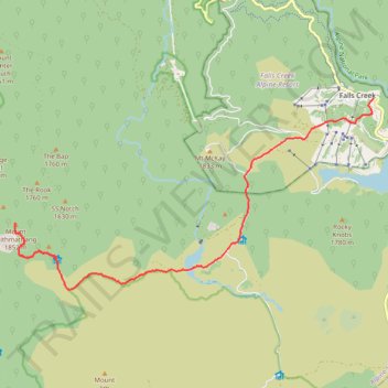
Mount Jaithmathang to Falls Creek
Falls, Jaithmathang, Bogong
- Distance: 15.3 Km
- Elevation gain: 519 m
- Maximum elevation: 1,826 m
- Elevation loss: 588 m
- Minimum elevation: 1,578 m
- Moving time: 3 h 17 m
- Moving speed: 4.6 Km/h
- Maximum speed: 6.3 Km/h
- Total time: 4 h 58 m
- Global speed: 3.1 Km/h
Interactive trail map
Trail profile
- Distance: 15.3 Km
- Elevation gain: 519 m
- Maximum elevation: 1,826 m
- Elevation loss: 588 m
- Minimum elevation: 1,578 m
- Moving time: 3 h 17 m
- Moving speed: 4.6 Km/h
- Maximum speed: 6.3 Km/h
- Total time: 4 h 58 m
- Global speed: 3.1 Km/h
About this trail
Name: Mount Jaithmathang to Falls Creek trail, distance, elevation, map, profile, GPS track
Coordinates: -36.90424 147.19216 -36.86432 147.28593
Topography: Victoria topographic map, elevation, terrain
Other hiking, mountain biking, running and outdoor activity trails
Click on a trail to view its statistics, map and profile.
Fainter Firetrail to Mount Fainter in Alpine National Park
Australia > Victoria > Falls Creek Alpine Resort > Falls Creek
Distance: 40.9 Km • Elevation gain: 957 m • Maximum elevation: 1,837 m
Tawonga Huts to Rocky Valley Storage via Pretty Valley Pondage in Australian Alps
Distance: 11.8 Km • Elevation gain: 313 m • Maximum elevation: 1,809 m
Cope Hut to Mount Jaithmatang and Tawanga Huts in Autralian Alps
Distance: 15.0 Km • Elevation gain: 395 m • Maximum elevation: 1,826 m