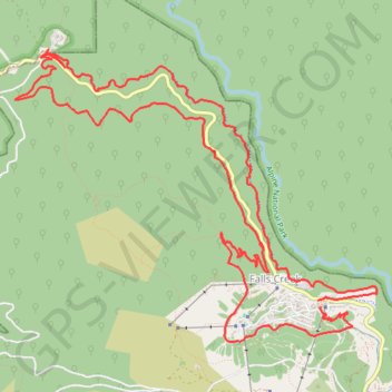
Falls Creek - Aqueduct Trail - Wishing Well - Flowtown - Packhorse Trail
Interactive trail map
Trail profile
- Distance: 17.1 Km
- Elevation gain: 614 m
- Maximum elevation: 1,612 m
- Elevation loss: 622 m
- Minimum elevation: 1,246 m
About this trail
Name: Falls Creek - Aqueduct Trail - Wishing Well - Flowtown - Packhorse Trail trail, distance, elevation, map, profile, GPS track
Coordinates: -36.86705 147.24846 -36.84172 147.28767
Topography: Falls Creek Alpine Resort topographic map, elevation, terrain
Other hiking, mountain biking, running and outdoor activity trails
Click on a trail to view its statistics, map and profile.
Fainter Firetrail to Mount Fainter in Alpine National Park
Australia > Victoria > Falls Creek Alpine Resort > Falls Creek
Distance: 40.9 Km • Elevation gain: 957 m • Maximum elevation: 1,837 m
Mount Jaithmathang to Falls Creek
Falls, Jaithmathang, Bogong
Distance: 15.3 Km • Elevation gain: 519 m • Maximum elevation: 1,826 m