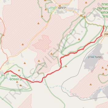
Yeruham Crater to Midreshet Ben Gurion
מכתש ירוחם למדרשת בן גוריון: מכתש גדול וטעימה ממדבר צין
- Distance: 34.3 Km
- Elevation gain: 1,311 m
- Maximum elevation: 679 m
- Elevation loss: 1,131 m
- Minimum elevation: 266 m
- Moving time: 10 h 12 m
- Moving speed: 3.4 Km/h
- Maximum speed: 4.2 Km/h
- Total time: 10 h 12 m
- Global speed: 3.4 Km/h
Interactive trail map
Trail profile
- Distance: 34.3 Km
- Elevation gain: 1,311 m
- Maximum elevation: 679 m
- Elevation loss: 1,131 m
- Minimum elevation: 266 m
- Moving time: 10 h 12 m
- Moving speed: 3.4 Km/h
- Maximum speed: 4.2 Km/h
- Total time: 10 h 12 m
- Global speed: 3.4 Km/h
About this trail
Name: Yeruham Crater to Midreshet Ben Gurion trail, distance, elevation, map, profile, GPS track
Coordinates: 30.83407 34.78503 30.95165 35.02653
Other hiking, mountain biking, running and outdoor activity trails
Click on a trail to view its statistics, map and profile.
Nahal Shualim to Midreshet Ben-Gurion
Israel > South District > Yeruham
נחל שועלים ורכס חתירה: קו גדול מירוחם למדרשת בן גוריון דרך נחל דרוך
Distance: 38.1 Km • Elevation gain: 840 m • Maximum elevation: 687 m
חיתוך בתוך המכתש הגדול, מנחל חתירה לסנפיר
Israel > South District > Ramat Negev Regional Council
Distance: 33.1 Km • Elevation gain: 1,105 m • Maximum elevation: 681 m
Mashashit and Tzayad Hike
Israel > South District > Ramat Negev Regional Council
ממשית והר צייד: דרך שרידי עיר נבטית ושמורת מצלעות המכתש הגדול
Distance: 32.3 Km • Elevation gain: 775 m • Maximum elevation: 654 m
Yeruham Crater - Karbolet
Israel > South District > Ramat Negev Regional Council
מכתש ירוחם והר כרבולת: מעגלי קטן בתוך המכתש הגדול
Distance: 18.9 Km • Elevation gain: 649 m • Maximum elevation: 571 m
Yeruham Crater Circle
Israel > South District > Ramat Negev Regional Council
סובב מכתש ירוחם: קו פנורמי, אלגנטי וגדול סביב תופעת טבע עוצרת נשימה
Distance: 40.4 Km • Elevation gain: 1,586 m • Maximum elevation: 687 m
Hod Ekev and Mount Tzror
Israel > South District > Ramat Negev Regional Council > Midreshet Ben-Gurion
חוד עקב והר צרור: מעלה דבשון, עין עקב וגב צרור
Distance: 21.9 Km • Elevation gain: 707 m • Maximum elevation: 556 m
קישור בין נחל דרוך לנחל תלול
Israel > South District > Ramat Negev Regional Council > Midreshet Ben-Gurion
Distance: 32.3 Km • Elevation gain: 672 m • Maximum elevation: 627 m
קישור בין נחל זקוף לנחל דרוך
Israel > South District > Ramat Negev Regional Council > Merchav Am
Distance: 38.0 Km • Elevation gain: 839 m • Maximum elevation: 675 m
עין ושרף פוביצר
Israel > South District > Arava Tichona Regional Council
Distance: 36.5 Km • Elevation gain: 936 m • Maximum elevation: 471 m