Hod Ekev and Mount Tzror
חוד עקב והר צרור: מעלה דבשון, עין עקב וגב צרור
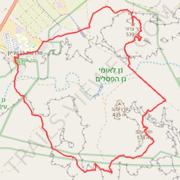
- Distance: 21.9 Km
- Elevation gain: 707 m
- Maximum elevation: 556 m
- Elevation loss: 707 m
- Minimum elevation: 314 m
Interactive trail map
Trail profile
- Distance: 21.9 Km
- Elevation gain: 707 m
- Maximum elevation: 556 m
- Elevation loss: 707 m
- Minimum elevation: 314 m
About this trail
Name: Hod Ekev and Mount Tzror trail, distance, elevation, map, profile, GPS track
Coordinates: 30.81447 34.77877 30.86562 34.83290
Other hiking, mountain biking, running and outdoor activity trails
Click on a trail to view its statistics, map and profile.
Nahal Shualim to Midreshet Ben-Gurion
Israel > South District > Yeruham
נחל שועלים ורכס חתירה: קו גדול מירוחם למדרשת בן גוריון דרך נחל דרוך
Distance: 38.1 Km • Elevation gain: 840 m • Maximum elevation: 687 m
Yeruham Crater to Midreshet Ben Gurion
Israel > South District > Ramat Negev Regional Council
מכתש ירוחם למדרשת בן גוריון: מכתש גדול וטעימה ממדבר צין
Distance: 34.3 Km • Elevation gain: 1,311 m • Maximum elevation: 679 m
קישור בין נחל דרוך לנחל תלול
Israel > South District > Ramat Negev Regional Council > Midreshet Ben-Gurion
Distance: 32.3 Km • Elevation gain: 672 m • Maximum elevation: 627 m
קישור בין נחל זקוף לנחל דרוך
Israel > South District > Ramat Negev Regional Council > Merchav Am
Distance: 38.0 Km • Elevation gain: 839 m • Maximum elevation: 675 m