Mashashit and Tzayad Hike
ממשית והר צייד: דרך שרידי עיר נבטית ושמורת מצלעות המכתש הגדול
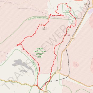
- Distance: 32.3 Km
- Elevation gain: 775 m
- Maximum elevation: 654 m
- Elevation loss: 776 m
- Minimum elevation: 283 m
- Moving time: 8 h 53 m
- Moving speed: 3.6 Km/h
- Maximum speed: 4.1 Km/h
- Total time: 8 h 53 m
- Global speed: 3.6 Km/h
Interactive trail map
Trail profile
- Distance: 32.3 Km
- Elevation gain: 775 m
- Maximum elevation: 654 m
- Elevation loss: 776 m
- Minimum elevation: 283 m
- Moving time: 8 h 53 m
- Moving speed: 3.6 Km/h
- Maximum speed: 4.1 Km/h
- Total time: 8 h 53 m
- Global speed: 3.6 Km/h
About this trail
Name: Mashashit and Tzayad Hike trail, distance, elevation, map, profile, GPS track
Coordinates: 30.94749 35.00608 31.03212 35.07408
Other hiking, mountain biking, running and outdoor activity trails
Click on a trail to view its statistics, map and profile.
Yeruham Crater to Midreshet Ben Gurion
Israel > South District > Ramat Negev Regional Council
מכתש ירוחם למדרשת בן גוריון: מכתש גדול וטעימה ממדבר צין
Distance: 34.3 Km • Elevation gain: 1,311 m • Maximum elevation: 679 m
חיתוך בתוך המכתש הגדול, מנחל חתירה לסנפיר
Israel > South District > Ramat Negev Regional Council
Distance: 33.1 Km • Elevation gain: 1,105 m • Maximum elevation: 681 m
Yeruham Crater - Karbolet
Israel > South District > Ramat Negev Regional Council
מכתש ירוחם והר כרבולת: מעגלי קטן בתוך המכתש הגדול
Distance: 18.9 Km • Elevation gain: 649 m • Maximum elevation: 571 m
Yeruham Crater Circle
Israel > South District > Ramat Negev Regional Council
סובב מכתש ירוחם: קו פנורמי, אלגנטי וגדול סביב תופעת טבע עוצרת נשימה
Distance: 40.4 Km • Elevation gain: 1,586 m • Maximum elevation: 687 m
Ein Yorkeam - Tzafir
Israel > South District > Ramat Negev Regional Council
עין ירקעם ומיצד צפיר: נחל חתירה, מעלה ימין וגב ימין
Distance: 19.7 Km • Elevation gain: 572 m • Maximum elevation: 477 m