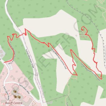
Import a GPX file

Tunnel Mountain

Banff National Park. #Hiking #Banff

  • Distance: 4.5 Km
  • Elevation gain: 291 m
  • Maximum elevation: 1,685 m
  • Elevation loss: 291 m
  • Minimum elevation: 1,426 m

Interactive trail map

Trail profile

  • Distance: 4.5 Km
  • Elevation gain: 291 m
  • Maximum elevation: 1,685 m
  • Elevation loss: 291 m
  • Minimum elevation: 1,426 m

About this trail

Name: Tunnel Mountain trail, distance, elevation, map, profile, GPS track

Start: 132, Saint Julien Road, Banff Centre District, Banff, Alberta, T1L 1H5, Canada (51.17541 -115.56201)

End: 132, Saint Julien Road, Banff Centre District, Banff, Alberta, T1L 1H5, Canada (51.17541 -115.56201)

Coordinates: 51.17432 -115.56201 51.17773 -115.55189

Other hiking, mountain biking, running and outdoor activity trails

Click on a trail to view its statistics, map and profile.

Bow Falls - Bow River - Banff

Canada > Alberta > Improvement District No. 9

Banff National Park. #Hiking #Trail #Banff

Distance: 7.8 Km • Elevation gain: 261 m • Maximum elevation: 1,563 m

Gear up for your next adventure:

🐍Snake Gaiters - Protection against snake bites
🥤Outdoor Water Bottles - Reusable bottles for outdoor activities
🎨Portable Watercolor Kits - Paint the landscapes and topographic views you discover
🎒Tactical Waist Packs - Quick access to your compass, phone, and snacks while walking
🔥Camping Stoves - Portable stoves for outdoor cooking

As an Amazon Associate, this site earns from qualifying purchases at no extra cost to you.