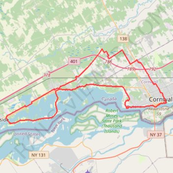
Cornwall Cycling
- Distance: 57.3 Km
- Elevation gain: 333 m
- Maximum elevation: 88 m
- Elevation loss: 330 m
- Minimum elevation: 47 m
- Moving time: 2 h 40 m
- Moving speed: 21.4 Km/h
- Maximum speed: 33.7 Km/h
- Total time: 3 h 5 m
- Global speed: 18.6 Km/h
Interactive trail map
Trail profile
- Distance: 57.3 Km
- Elevation gain: 333 m
- Maximum elevation: 88 m
- Elevation loss: 330 m
- Minimum elevation: 47 m
- Moving time: 2 h 40 m
- Moving speed: 21.4 Km/h
- Maximum speed: 33.7 Km/h
- Total time: 3 h 5 m
- Global speed: 18.6 Km/h
About this trail
Name: Cornwall Cycling trail, distance, elevation, map, profile, GPS track
Start: 167, Sixth Street East, Cornwall, Eastern Ontario, Ontario, K6H 3R3, Canada (45.02543 -74.72822)
End: 214, Sixth Street East, Cornwall, Eastern Ontario, Ontario, K6H 3R3, Canada (45.02536 -74.72766)
Coordinates: 44.99050 -74.97416 45.07437 -74.72107
Other hiking, mountain biking, running and outdoor activity trails
Click on a trail to view its statistics, map and profile.
Brockville - Lancaster
Canada > Ontario > Brockville > Brockville
Saint-Laurent River. #Bike #SaintLaurent
Distance: 135.3 Km • Elevation gain: 489 m • Maximum elevation: 101 m
Brockville - Cornwall
Canada > Ontario > Brockville > Brockville
#Bike
Distance: 100.0 Km • Elevation gain: 298 m • Maximum elevation: 102 m
Cornwall Bike Path Loop
Canada > Ontario > Cornwall > Cornwall
Distance: 30.3 Km • Elevation gain: 154 m • Maximum elevation: 69 m
Guindon Park Hike
Canada > Ontario > Cornwall > Cornwall
Distance: 6.3 Km • Elevation gain: 21 m • Maximum elevation: 74 m