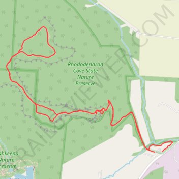
Rhododendron Cove Trails
- Distance: 3.6 Km
- Elevation gain: 118 m
- Maximum elevation: 320 m
- Elevation loss: 119 m
- Minimum elevation: 234 m
- Moving time: 57 m 49 s
- Moving speed: 3.8 Km/h
- Maximum speed: 36.8 Km/h
- Total time: 1 h 30 m
- Global speed: 2.4 Km/h
Interactive trail map
Trail profile
About this trail
Name: Rhododendron Cove Trails trail, distance, elevation, map, profile, GPS track
Coordinates: 39.63161 -82.56791 39.63736 -82.55802
Other hiking, mountain biking, running and outdoor activity trails
Click on a trail to view its statistics, map and profile.