Rhododendron Cove Nature Preserve Trails
Loop hike in the Rhododendron Cove Nature Preserve and the Wahkeena Nature Preserve. #Hiking #Loop #Nature #Forest
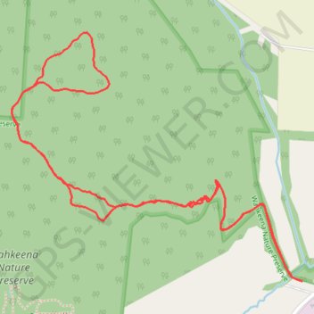
- Distance: 3.3 Km
- Elevation gain: 122 m
- Maximum elevation: 320 m
- Elevation loss: 122 m
- Minimum elevation: 235 m
- Moving time: 59 m 29 s
- Moving speed: 3.3 Km/h
- Maximum speed: 11.2 Km/h
- Total time: 1 h 27 m
- Global speed: 2.3 Km/h
Interactive trail map
Trail profile
- Distance: 3.3 Km
- Elevation gain: 122 m
- Maximum elevation: 320 m
- Elevation loss: 122 m
- Minimum elevation: 235 m
- Moving time: 59 m 29 s
- Moving speed: 3.3 Km/h
- Maximum speed: 11.2 Km/h
- Total time: 1 h 27 m
- Global speed: 2.3 Km/h
About this trail
Name: Rhododendron Cove Nature Preserve Trails trail, distance, elevation, map, profile, GPS track
Coordinates: 39.63166 -82.56791 39.63735 -82.55925
Other hiking, mountain biking, running and outdoor activity trails
Click on a trail to view its statistics, map and profile.
Rhododendron Cove Trails
United States > Ohio > Fairfield County > Blue Valley Acres
Distance: 3.6 Km • Elevation gain: 118 m • Maximum elevation: 320 m