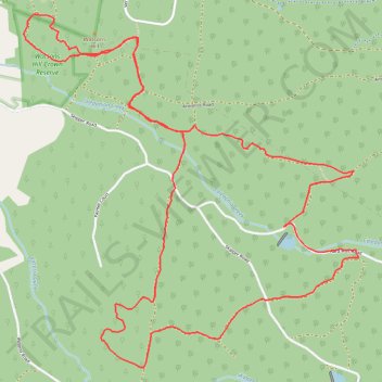
Hard Hills and Watsons Hill Diggings - Ross Creek State Forest
- Distance: 10.8 Km
- Elevation gain: 159 m
- Maximum elevation: 436 m
- Elevation loss: 159 m
- Minimum elevation: 371 m
Interactive trail map
Trail profile
- Distance: 10.8 Km
- Elevation gain: 159 m
- Maximum elevation: 436 m
- Elevation loss: 159 m
- Minimum elevation: 371 m
About this trail
Name: Hard Hills and Watsons Hill Diggings - Ross Creek State Forest trail, distance, elevation, map, profile, GPS track
Start: Hard Hills Road, Scarsdale, Golden Plains Shire, Victoria, 3351, Australia (-37.67196 143.70469)
End: Hard Hills Road, Scarsdale, Golden Plains Shire, Victoria, 3351, Australia (-37.67201 143.70463)
Coordinates: -37.68046 143.68483 -37.65919 143.71031
Topography: Victoria topographic map, elevation, terrain
Other hiking, mountain biking, running and outdoor activity trails
Click on a trail to view its statistics, map and profile.
Watsons Hill Loop
Australia > Victoria > Smythesdale
Distance: 4.8 Km • Elevation gain: 70 m • Maximum elevation: 405 m