Make a donation
Gear up for your next adventure:
As an Amazon Associate, this site earns from qualifying purchases at no extra cost to you.
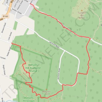
Watsons Hill Loop
- Distance: 4.8 Km
- Elevation gain: 70 m
- Maximum elevation: 405 m
- Elevation loss: 65 m
- Minimum elevation: 363 m
Interactive trail map
Make a donation
Gear up for your next adventure:
As an Amazon Associate, this site earns from qualifying purchases at no extra cost to you.
Trail profile
- Distance: 4.8 Km
- Elevation gain: 70 m
- Maximum elevation: 405 m
- Elevation loss: 65 m
- Minimum elevation: 363 m
Make a donation
Gear up for your next adventure:
As an Amazon Associate, this site earns from qualifying purchases at no extra cost to you.
About this trail
Name: Watsons Hill Loop trail, distance, elevation, map, profile, GPS track
Start: 45, Pascoe Street, Smythesdale, Golden Plains Shire, Victoria, 3351, Australia (-37.64665 143.68689)
Coordinates: -37.66173 143.68313 -37.64665 143.69911
Topography: Victoria topographic map, elevation, terrain
Make a donation
Gear up for your next adventure:
As an Amazon Associate, this site earns from qualifying purchases at no extra cost to you.
Other hiking, mountain biking, running and outdoor activity trails
Click on a trail to view its statistics, map and profile.
Hard Hills and Watsons Hill Diggings - Ross Creek State Forest
Distance: 10.8 Km • Elevation gain: 159 m • Maximum elevation: 436 m