Make a donation
Gear up for your next adventure:
As an Amazon Associate, this site earns from qualifying purchases at no extra cost to you.
Mucanj-vrhovi
- Distance: 8.8 Km
- Elevation gain: 0 m
- Maximum elevation: 1,502 m
- Elevation loss: 126 m
- Minimum elevation: 1,375 m
Interactive trail map
Make a donation
Gear up for your next adventure:
As an Amazon Associate, this site earns from qualifying purchases at no extra cost to you.
Trail profile
- Distance: 8.8 Km
- Elevation gain: 0 m
- Maximum elevation: 1,502 m
- Elevation loss: 126 m
- Minimum elevation: 1,375 m
Make a donation
Gear up for your next adventure:
As an Amazon Associate, this site earns from qualifying purchases at no extra cost to you.
About this trail
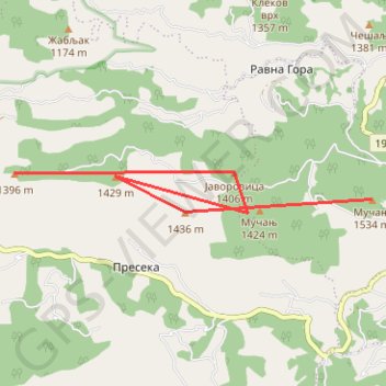
Name: Mucanj-vrhovi trail, distance, elevation, map, profile, GPS track
Coordinates: 43.54375 19.97647 43.54858 20.03477
Make a donation
Gear up for your next adventure:
As an Amazon Associate, this site earns from qualifying purchases at no extra cost to you.
Other hiking, mountain biking, running and outdoor activity trails
Click on a trail to view its statistics, map and profile.
2022_Yu
Slovenia > Ajdovščina > Žapuže
Distance: 2,457.3 Km • Elevation gain: 32,048 m • Maximum elevation: 1,950 m
Track 001
Serbia > Central Serbia > Moravica Administrative District > Ivanjica Municipality > Katici
Distance: 16.5 Km • Elevation gain: 621 m • Maximum elevation: 1,517 m