Make a donation
Gear up for your next adventure:
As an Amazon Associate, this site earns from qualifying purchases at no extra cost to you.
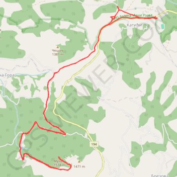
Track 001
- Distance: 16.5 Km
- Elevation gain: 621 m
- Maximum elevation: 1,517 m
- Elevation loss: 620 m
- Minimum elevation: 1,029 m
- Moving time: 3 h 41 m
- Moving speed: 4.5 Km/h
- Maximum speed: 10.0 Km/h
- Total time: 4 h 12 m
- Global speed: 3.9 Km/h
Interactive trail map
Make a donation
Gear up for your next adventure:
As an Amazon Associate, this site earns from qualifying purchases at no extra cost to you.
Trail profile
- Distance: 16.5 Km
- Elevation gain: 621 m
- Maximum elevation: 1,517 m
- Elevation loss: 620 m
- Minimum elevation: 1,029 m
- Moving time: 3 h 41 m
- Moving speed: 4.5 Km/h
- Maximum speed: 10.0 Km/h
- Total time: 4 h 12 m
- Global speed: 3.9 Km/h
Make a donation
Gear up for your next adventure:
As an Amazon Associate, this site earns from qualifying purchases at no extra cost to you.
About this trail
Name: Track 001 trail, distance, elevation, map, profile, GPS track
Coordinates: 43.54288 20.02437 43.57376 20.06024
Make a donation
Gear up for your next adventure:
As an Amazon Associate, this site earns from qualifying purchases at no extra cost to you.
Other hiking, mountain biking, running and outdoor activity trails
Click on a trail to view its statistics, map and profile.
2022_Yu
Slovenia > Ajdovščina > Žapuže
Distance: 2,457.3 Km • Elevation gain: 32,048 m • Maximum elevation: 1,950 m
Mucanj-vrhovi
Serbia > Central Serbia > Moravica Administrative District > Ivanjica Municipality > Ravna Gora
Distance: 8.8 Km • Elevation gain: 0 m • Maximum elevation: 1,502 m