Armitage Bridge, Butternab Wood and Beaumont Park Loop Hike
- Distance: 6.7 Km
- Elevation gain: 155 m
- Maximum elevation: 207 m
- Elevation loss: 156 m
- Minimum elevation: 82 m
- Moving time: 2 h 48 m
- Moving speed: 2.4 Km/h
- Maximum speed: 4.5 Km/h
- Total time: 3 h 29 m
- Global speed: 1.9 Km/h
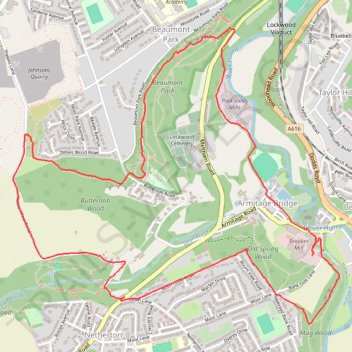
Interactive trail map
Trail profile
- Distance: 6.7 Km
- Elevation gain: 155 m
- Maximum elevation: 207 m
- Elevation loss: 156 m
- Minimum elevation: 82 m
- Moving time: 2 h 48 m
- Moving speed: 2.4 Km/h
- Maximum speed: 4.5 Km/h
- Total time: 3 h 29 m
- Global speed: 1.9 Km/h
About this trail
Name: Armitage Bridge, Butternab Wood and Beaumont Park Loop Hike trail, distance, elevation, map, profile, GPS track
Coordinates: 53.61477 -1.82124 53.62834 -1.79601
Other hiking, mountain biking, running and outdoor activity trails
Click on a trail to view its statistics, map and profile.
Netherton woods circular
United Kingdom > England > Kirklees > Netherton
Distance: 6.3 Km • Elevation gain: 147 m • Maximum elevation: 204 m