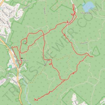
Wildcat Ridge Wildlife Management Area
Description:
- Distance: 12.2 Km
- Elevation gain: 332 m
- Maximum elevation: 322 m
- Elevation loss: 333 m
- Minimum elevation: 168 m
- Moving time: 2 h 38 m
- Moving speed: 4.6 Km/h
- Maximum speed: 15.7 Km/h
- Total time: 3 h 15 m
- Global speed: 3.7 Km/h
Interactive trail map
Trail profile
- Distance: 12.2 Km
- Elevation gain: 332 m
- Maximum elevation: 322 m
- Elevation loss: 333 m
- Minimum elevation: 168 m
- Moving time: 2 h 38 m
- Moving speed: 4.6 Km/h
- Maximum speed: 15.7 Km/h
- Total time: 3 h 15 m
- Global speed: 3.7 Km/h
About this trail
Name: Wildcat Ridge Wildlife Management Area trail, distance, elevation, map, profile, GPS track
Coordinates: 40.93775 -74.49505 40.95845 -74.47207
Other hiking, mountain biking, running and outdoor activity trails
Click on a trail to view its statistics, map and profile.
Wildcat Ridge Wildlife Management Area - Lake Telemark Loop
United States > New Jersey > Morris County > Rockaway Township > Lake Telemark > Hibernia
Distance: 18.2 Km • Elevation gain: 370 m • Maximum elevation: 287 m
Wildcat Ridge Loop
United States > New Jersey > Morris County > Rockaway Township > Hibernia
Distance: 29.4 Km • Elevation gain: 615 m • Maximum elevation: 312 m