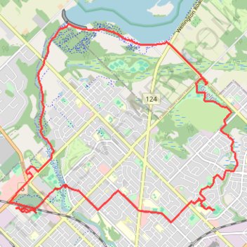
Paths and trails in Guelph
- Distance: 20.0 Km
- Elevation gain: 133 m
- Maximum elevation: 366 m
- Elevation loss: 133 m
- Minimum elevation: 327 m
- Moving time: 1 h 17 m
- Moving speed: 15.5 Km/h
- Maximum speed: 35.2 Km/h
- Total time: 1 h 35 m
- Global speed: 12.5 Km/h
Interactive trail map
Trail profile
- Distance: 20.0 Km
- Elevation gain: 133 m
- Maximum elevation: 366 m
- Elevation loss: 133 m
- Minimum elevation: 327 m
- Moving time: 1 h 17 m
- Moving speed: 15.5 Km/h
- Maximum speed: 35.2 Km/h
- Total time: 1 h 35 m
- Global speed: 12.5 Km/h
About this trail
Name: Paths and trails in Guelph trail, distance, elevation, map, profile, GPS track
Coordinates: 43.55764 -80.28229 43.59437 -80.22407
Other hiking, mountain biking, running and outdoor activity trails
Click on a trail to view its statistics, map and profile.
Ontario country roads
Distance: 150.4 Km • Elevation gain: 1,137 m • Maximum elevation: 497 m
Phoenix MTB Trail
Distance: 3.3 Km • Elevation gain: 35 m • Maximum elevation: 361 m