Thank you for supporting this site ❤️
Make a donation
Make a donation
Gear up for your next adventure:
As an Amazon Associate, this site earns from qualifying purchases at no extra cost to you.
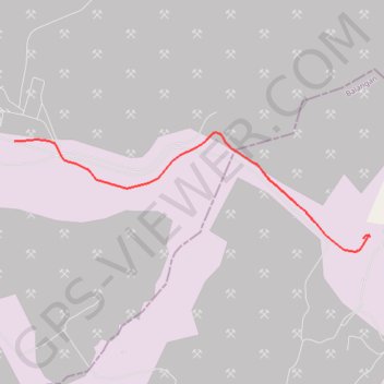
CYCLE 1 003
- Distance: 5.6 Km
- Elevation gain: 94 m
- Maximum elevation: 115 m
- Elevation loss: 117 m
- Minimum elevation: 44 m
- Moving time: 16 m 23 s
- Moving speed: 20.5 Km/h
- Maximum speed: 41.1 Km/h
- Total time: 19 m 12 s
- Global speed: 17.5 Km/h
Interactive trail map
Thank you for supporting this site ❤️
Make a donation
Make a donation
Gear up for your next adventure:
As an Amazon Associate, this site earns from qualifying purchases at no extra cost to you.
Trail profile
- Distance: 5.6 Km
- Elevation gain: 94 m
- Maximum elevation: 115 m
- Elevation loss: 117 m
- Minimum elevation: 44 m
- Moving time: 16 m 23 s
- Moving speed: 20.5 Km/h
- Maximum speed: 41.1 Km/h
- Total time: 19 m 12 s
- Global speed: 17.5 Km/h
Thank you for supporting this site ❤️
Make a donation
Make a donation
Gear up for your next adventure:
As an Amazon Associate, this site earns from qualifying purchases at no extra cost to you.
About this trail
Name: CYCLE 1 003 trail, distance, elevation, map, profile, GPS track
Coordinates: -2.17342 115.54329 -2.16033 115.58237
Thank you for supporting this site ❤️
Make a donation
Make a donation
Gear up for your next adventure:
As an Amazon Associate, this site earns from qualifying purchases at no extra cost to you.
Other hiking, mountain biking, running and outdoor activity trails
Click on a trail to view its statistics, map and profile.
CYCLE 1 003
Indonesia > South Kalimantan > Balangan
Distance: 5.6 Km • Elevation gain: 94 m • Maximum elevation: 115 m