Thank you for supporting this site ❤️
Make a donation
Make a donation
Gear up for your next adventure:
As an Amazon Associate, this site earns from qualifying purchases at no extra cost to you.
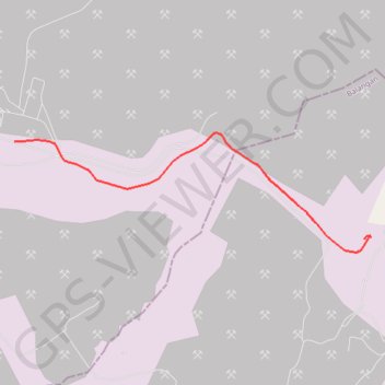
CYCLE 1 003
- Distance: 5.6 Km
- Elevation gain: 94 m
- Maximum elevation: 115 m
- Elevation loss: 117 m
- Minimum elevation: 44 m
- Moving time: 16 m 23 s
- Moving speed: 20.5 Km/h
- Maximum speed: 41.1 Km/h
- Total time: 19 m 12 s
- Global speed: 17.5 Km/h
Interactive trail map
Thank you for supporting this site ❤️
Make a donation
Make a donation
Gear up for your next adventure:
As an Amazon Associate, this site earns from qualifying purchases at no extra cost to you.
Trail profile
- Distance: 5.6 Km
- Elevation gain: 94 m
- Maximum elevation: 115 m
- Elevation loss: 117 m
- Minimum elevation: 44 m
- Moving time: 16 m 23 s
- Moving speed: 20.5 Km/h
- Maximum speed: 41.1 Km/h
- Total time: 19 m 12 s
- Global speed: 17.5 Km/h
Thank you for supporting this site ❤️
Make a donation
Make a donation
Gear up for your next adventure:
As an Amazon Associate, this site earns from qualifying purchases at no extra cost to you.
About this trail
Name: CYCLE 1 003 trail, distance, elevation, map, profile, GPS track
Coordinates: -2.17342 115.54329 -2.16033 115.58237
Thank you for supporting this site ❤️
Make a donation
Make a donation
Gear up for your next adventure:
🐍Australian Snake Bite Kits - Specific pressure immobilization bandages for Australian venomous snakes
As an Amazon Associate, this site earns from qualifying purchases at no extra cost to you.
Other hiking, mountain biking, running and outdoor activity trails
Click on a trail to view its statistics, map and profile.
CYCLE 1 003
Indonesia > South Kalimantan > Balangan
Distance: 5.6 Km • Elevation gain: 94 m • Maximum elevation: 115 m