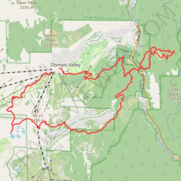
Thunder Mountain Trail, Five Lakes Trail, Bear Creek Trail and Western States Trail Loop in Tahoe National Forest
- Distance: 26.9 Km
- Elevation gain: 1,178 m
- Maximum elevation: 2,355 m
- Elevation loss: 1,187 m
- Minimum elevation: 1,885 m
- Moving time: 4 h 33 m
- Moving speed: 5.9 Km/h
- Maximum speed: 22.6 Km/h
- Total time: 4 h 49 m
- Global speed: 5.6 Km/h
Interactive trail map
Trail profile
- Distance: 26.9 Km
- Elevation gain: 1,178 m
- Maximum elevation: 2,355 m
- Elevation loss: 1,187 m
- Minimum elevation: 1,885 m
- Moving time: 4 h 33 m
- Moving speed: 5.9 Km/h
- Maximum speed: 22.6 Km/h
- Total time: 4 h 49 m
- Global speed: 5.6 Km/h
About this trail
Name: Thunder Mountain Trail, Five Lakes Trail, Bear Creek Trail and Western States Trail Loop in Tahoe National Forest trail, distance, elevation, map, profile, GPS track
Coordinates: 39.17546 -120.25489 39.20413 -120.18311
Other hiking, mountain biking, running and outdoor activity trails
Click on a trail to view its statistics, map and profile.
Five Lakes Loop
United States > California > Placer County > Alpine Meadows
Starting at the Five Lakes Trailhead near Alpine Meadows Road, the route follows the Five Lakes Trail away from the developed valley and climbs through open Sierra slopes, scattered conifers, and granite-studded terrain toward the edge of Tahoe National Forest. The path then enters the Granite Chief…
Distance: 9.9 Km • Elevation gain: 438 m • Maximum elevation: 2,317 m
Thunder Mountain Trail and Western States Trail Loop in Tahoe National Forest
United States > California > Placer County > Olympic Valley
Distance: 5.1 Km • Elevation gain: 254 m • Maximum elevation: 2,120 m
Shirley Canyon to Granite Chief trail
United States > California > Placer County > Olympic Valley
Distance: 16.1 Km • Elevation gain: 852 m • Maximum elevation: 2,653 m
Broken Arrow 23k
United States > California > Placer County > Olympic Valley
Distance: 19.0 Km • Elevation gain: 1,274 m • Maximum elevation: 2,430 m
Broken Arrow 1-lapper
United States > California > Placer County > Olympic Valley
Distance: 23.4 Km • Elevation gain: 1,398 m • Maximum elevation: 2,705 m
Tahoe Rim Trail to Burtron Creek trails
United States > California > Placer County > Tahoe City
#TRT
Distance: 21.3 Km • Elevation gain: 608 m • Maximum elevation: 2,264 m
Shirley Lake trails
United States > California > Placer County
Distance: 7.9 Km • Elevation gain: 33 m • Maximum elevation: 2,659 m