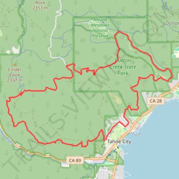
Tahoe Rim Trail to Burtron Creek trails
#TRT
- Distance: 21.3 Km
- Elevation gain: 608 m
- Maximum elevation: 2,264 m
- Elevation loss: 614 m
- Minimum elevation: 1,914 m
- Moving time: 3 h 8 m
- Moving speed: 6.8 Km/h
- Maximum speed: 17.5 Km/h
- Total time: 3 h 12 m
- Global speed: 6.6 Km/h
Interactive trail map
Trail profile
- Distance: 21.3 Km
- Elevation gain: 608 m
- Maximum elevation: 2,264 m
- Elevation loss: 614 m
- Minimum elevation: 1,914 m
- Moving time: 3 h 8 m
- Moving speed: 6.8 Km/h
- Maximum speed: 17.5 Km/h
- Total time: 3 h 12 m
- Global speed: 6.6 Km/h
About this trail
Name: Tahoe Rim Trail to Burtron Creek trails trail, distance, elevation, map, profile, GPS track
Coordinates: 39.16724 -120.18652 39.20142 -120.12324
Other hiking, mountain biking, running and outdoor activity trails
Click on a trail to view its statistics, map and profile.
Thunder Mountain Trail, Five Lakes Trail, Bear Creek Trail and Western States Trail Loop in Tahoe National Forest
United States > California > Placer County > Olympic Valley
Distance: 26.9 Km • Elevation gain: 1,178 m • Maximum elevation: 2,355 m