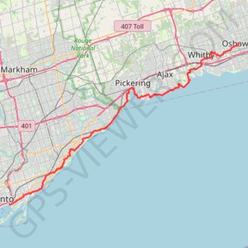
Toronto - Oshawa
#Bike
- Distance: 67.3 Km
- Elevation gain: 457 m
- Maximum elevation: 183 m
- Elevation loss: 420 m
- Minimum elevation: 73 m
Interactive trail map
Trail profile
- Distance: 67.3 Km
- Elevation gain: 457 m
- Maximum elevation: 183 m
- Elevation loss: 420 m
- Minimum elevation: 73 m
About this trail
Name: Toronto - Oshawa trail, distance, elevation, map, profile, GPS track
Coordinates: 43.64375 -79.35837 43.89811 -78.86068
Other hiking, mountain biking, running and outdoor activity trails
Click on a trail to view its statistics, map and profile.
Biidaasige Park and Tommy Thompson Park Loop Ride
Distance: 20.5 Km • Elevation gain: 67 m • Maximum elevation: 82 m
Scarborough - Cobourg
Lake Ontario. #Bike #Scarborough #Cobourg #Toronto #Ontario
Distance: 107.4 Km • Elevation gain: 717 m • Maximum elevation: 130 m
Brampton - Scarborough
Canada > Ontario > Peel Region > Brampton
Lake Ontario. #Bike #Brampton #Scarborough #Toronto #Ontario
Distance: 73.2 Km • Elevation gain: 570 m • Maximum elevation: 184 m
Hamilton - Toronto
#Bike
Distance: 81.3 Km • Elevation gain: 458 m • Maximum elevation: 111 m
Serena Gundy Park
Distance: 1.3 Km • Elevation gain: 29 m • Maximum elevation: 129 m
The Meadoway: Midland to Marcos section
Distance: 1.5 Km • Elevation gain: 4 m • Maximum elevation: 162 m