Thank you for supporting this site ❤️
Make a donation
Make a donation
Gear up for your next adventure:
As an Amazon Associate, this site earns from qualifying purchases at no extra cost to you.
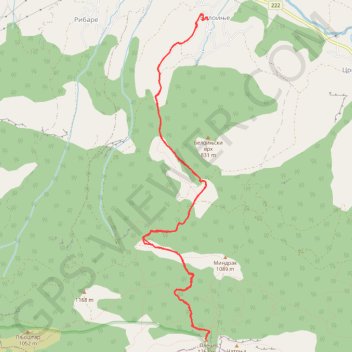
Beloinje-Pleš
- Distance: 13.5 Km
- Elevation gain: 863 m
- Maximum elevation: 1,257 m
- Elevation loss: 863 m
- Minimum elevation: 417 m
- Moving time: 5 h 10 m
- Moving speed: 2.6 Km/h
- Maximum speed: 7.5 Km/h
- Total time: 8 h 56 m
- Global speed: 1.5 Km/h
Interactive trail map
Thank you for supporting this site ❤️
Make a donation
Make a donation
Gear up for your next adventure:
As an Amazon Associate, this site earns from qualifying purchases at no extra cost to you.
Trail profile
- Distance: 13.5 Km
- Elevation gain: 863 m
- Maximum elevation: 1,257 m
- Elevation loss: 863 m
- Minimum elevation: 417 m
- Moving time: 5 h 10 m
- Moving speed: 2.6 Km/h
- Maximum speed: 7.5 Km/h
- Total time: 8 h 56 m
- Global speed: 1.5 Km/h
Thank you for supporting this site ❤️
Make a donation
Make a donation
Gear up for your next adventure:
As an Amazon Associate, this site earns from qualifying purchases at no extra cost to you.
About this trail
Name: Beloinje-Pleš trail, distance, elevation, map, profile, GPS track
Coordinates: 43.35404 22.15448 43.39314 22.16544
Thank you for supporting this site ❤️
Make a donation
Make a donation
Gear up for your next adventure:
As an Amazon Associate, this site earns from qualifying purchases at no extra cost to you.