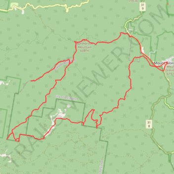
Northbrook Mountain, England Creek and back up via Joyners Break
- Distance: 40.1 Km
- Elevation gain: 1,749 m
- Maximum elevation: 706 m
- Elevation loss: 1,748 m
- Minimum elevation: 80 m
- Moving time: 6 h 24 m
- Moving speed: 6.3 Km/h
- Maximum speed: 49.9 Km/h
- Total time: 8 h 8 m
- Global speed: 4.9 Km/h
Interactive trail map
Trail profile
- Distance: 40.1 Km
- Elevation gain: 1,749 m
- Maximum elevation: 706 m
- Elevation loss: 1,748 m
- Minimum elevation: 80 m
- Moving time: 6 h 24 m
- Moving speed: 6.3 Km/h
- Maximum speed: 49.9 Km/h
- Total time: 8 h 8 m
- Global speed: 4.9 Km/h
About this trail
Name: Northbrook Mountain, England Creek and back up via Joyners Break trail, distance, elevation, map, profile, GPS track
Coordinates: -27.37324 152.67954 -27.31836 152.77084
Topography: Queensland topographic map, elevation, terrain
Other hiking, mountain biking, running and outdoor activity trails
Click on a trail to view its statistics, map and profile.
D'Aguilar National Park - Mount Nebo - Cabbage Tree Creek
#MTB #Loop #Daguilar #Nebo #CabbageTree
Distance: 43.7 Km • Elevation gain: 1,569 m • Maximum elevation: 549 m
Northbrook Mountain & Gorge
Loop run / trail / hike via Northbrook Parkway, Wivenhoe Outlook, Switchback Road, Cattleyards Break, England Creek Road, Northbrook Mountain bush Camp, Northbrook Mountain, Lawton Road and Northbrook Gorge Trail in d'Aguilar National Park. #Running #Trail #Hiking #Mountain #Nature #Forest #Park
Distance: 24.5 Km • Elevation gain: 1,271 m • Maximum elevation: 624 m